On the Move: Big Island to Lanai
The seductiveness of a safe harbor cannot be overstated, especially when the harbor in question is not only safe but sunny and tranquil and has its own restaurant where the servers know your name and the fish tacos are excellent. Here the neighbors are friendly to a fault and the passers-by, inquisitive. “You really from San Francisco? And alone?”

Murre ready to depart Honokohau Harbor, Big Island
We had stayed almost a month in Kona and had little to show for it but an abiding satisfaction, a contentment that began to feel like belonging. Yet comfortable as it was, we knew Honokohau Harbor must be abandoned, and soon, if other islands were to be visited in any detail. Not many weeks remained of our Hawaii cruise; soon Murre would plunge into the North Pacific.
True to form, winds in the Alenuihaha Channel took my intentions toward departure as a sign to increase velocity and stack up waves like boulders. We were ready on a Sunday but had to wait until Thursday for a lull. This put Murre in a foul mood, forcing me to search for solitude (in the form of a baseball game) at the restaurant bar.
Suddenly what I had regarded on one day as a paradise became a prison the day after I’d resolved to leave. The men at the bar, men with large bellies and red faces, wanted to watch basketball. Basketball, of all things! Their fish stories, once so charming, were now loud and plain, and they reeked of their catch and stale beer just as the heavy air outside reeked of the volcano’s spew. How had I not noticed this before?
The weather service called for “stiff rough-water trades to diminish briefly on Friday before accelerating to near gale levels in front of a shear line approaching from the north.” I didn’t know what a shear line was and resolved not to find out, so on Thursday Murre and I motored in a flat calm (winds behind the islands are no indication of wind in the channels) to the staging anchorage, a run of 35 miles to a small depression in the coast just under the Big Island’s northwestern point called Nishimura Bay. From here the jump across the Alenuihaha would be the shortest. An hour from the bay and I saw a line of white water ahead. The mountains had finally fallen away to low hills and the ocean winds were pouring into the island’s lee like a river undammed. For a time I feared the wind had overwhelmed our anchorage, but her waters were flat as we eased in and dropped the hook in sand.

Anchored Nishimura Bay--really more of a roadstead
It saddened me that our second visit to Nishmura would also be brief, just one night, but we must stay ahead of the weather, and this would not allow for going ashore to explore the countryside. I cleaned and stowed below for a boisterous passage, put a reef in the main, laid out my foul weather gear, and set the alarm for 2:30am. But while I was cooking dinner the forecast changed. The arrival of big winds moved from Friday to Saturday night.
We’d get to stay a day.

Looking Southeast from Nishimura Bay--Mauna Loa Rises in the Background
*****
“I hope you know you are on private property,” said the man, approaching slowly. He was Hawaiian, held his long hair in a pony tail, his mouth vacant of several teeth. On his shirt the words “Kohala Perserve Grounds Crew”.
Earlier in the day I had beached Coot on the rocks above Nishimura Bay and begun the short walk to the hill on which stood an ancient Polynesian navigational heiau* that I could see from Murre, one of several such structures on the islands. But almost immediately I was stopped by a sign: “Kohala Preserve Private Property. This site is sacred to the Hawaiian people. Help us keep it for future generations. Please show your respect and stay away.”
It is one of the great curses of cruising, the No Trespassing sign, found a few steps from the beach on almost every island I’ve visited in the Pacific. One learns quickly that if anything at all is to be seen, such signs must be ignored.
However, in this case, and after a moment’s thought, I’d turned away. It was something to do with the wordsacred. I walked out toward Upolu Point over hills of rock and dry grass and scrub covered over with a thick, endless ocean wind; then back to the bay before Nishimura, now a disused landing for the town where white people snorkeled and locals fished; and then back to a neatly manicured knoll, also signed “Private Property”. Here I had lunch on a bit of lawn in the shade of an acacia tree while watching Murre pull with urgency at her anchor.
“Pardon?” I said.
“This property,” the man waved in such a way as to encompass the entire area I’d just traversed, “are you aware it’s all private?”
“I had no idea,” I said. The sign placers were far too conscientious for this lie to pass muster, so I followed up with, “I came by boat; that’s my dinghy on the rocks,” by way of diversion.

Coot on the Rocks with Murre behind. Note the line of whitecaps in the distance.
“I’m just saying in case someone hassles you, you know, that you’re not suppose to be here. I don’t care, personally, I mean. My name’s Luther.” The man stuck out his hand.
From Luther I learned that all the barren land from here to the point was held by a single company, that it had all been cut up for development, but only a few roads had been scraped into the hills before the project was abandoned. “OK by me,” he said. “I like it better just rock and dry grass. Except here the grass is green because I put water on it. We do weddings right here.”
“And the navigational heiau?” I said.
“What, you been up there?” His look was direct.
“Nope, I saw that sign. But it’s why I came ashore. Why’s it closed?”
“Vandals,” said Luther. “We had an old navigator here years ago who taught us all about the stars and he says the rocks point to Tahiti, New Zealand, California. But the kids like to tip them over so now we can’t find the piko stone (Hawaiian for belly button–i.e. center stone).”
“California?” I asked.
“Yes,” said Luther. He raised his right arm and pointed northeast. “That way.** If you’d like to see the heiau I give you my personal permission. If someone bothers you, just say ‘Luther said I could.'”
******
The navigational heiau is a jumble of volcanic rubble on top of which stand a number of obelisk-shaped stones of various sizes whose order is entirely unobvious. For example, Tahiti is nearly due south of Hawaii, but no stone combinations obviously pointed in that direction.
I have yet to find any scientific literature on this site.

Navigational Heiau above Nishimura Bay
–

Navigational Marker with Offerings of Cordage
*****
We departed at 3:30 in the morning under a moonless, starry sky–our day’s destination Manele Harbor on Lanai–and picked up the channel winds within twenty minutes. These were steady out of the northeast at between 17 and 22 knots. On nothing but her jib Murre flew along. Sunup came sweet and rich as cream, then it rose into mixed cloud that sprinkled on Murre for a time.

Murre in the Alenuihaha, Maui approaching
–
The channel crossing had been my worry, but it was between the islands that our trouble began. Wind died altogether once we’d come behind big Maui, as I had expected, but half an hour later it was 15 knots and wandering between southeast and southwest and then west, much to the wind vane’s consternation. Later the wind died again so that we motored until coming below the saddle that connects the two Mauis where wind was 20 from the north; then it was 20 from the east. An hour of this and we were again in flat calm. Two hours of motoring and we had opened the Pailolo Channel near Lanai in the southeast, and here winds came strongly from the north. But I had grown weary of the game and we motored the last hour into Manele, though we could have sailed well.
These shifting winds between the islands had cost me my favorite hat, which took flight on a sudden gust only to find its one wing, a bill in fact, could not carry it except into the waves. Then there was the ship’s logbook I had set down on the transom during one of the calms. I saw it floating there after the breeze and the chop started flinging water on to the decks and grabbed for it just as it was making for the scuppers.
We made tiny Manele Harbor at 3:30 in the afternoon, a good and easy passage of 65 miles in 12 hours.

Lanai's Manele Harbor, where life is slow and the picnic tables are free as long as one types quietly.
*****
*rock structure, often the foundation of an important building, like a temple or royal home, the rest of the building being made of wood and grass. Pronounced heyow. In such a vowel heavy language, remembering correct spellings is problematic. I tried spelling this word “haeiou” at first and was tempted to throw in “y” to ensure the bases were covered.
**I didn’t push the obvious point, that there is no evidence Hawaiians knew of North America, much less a particular part of it named in modern times by Europeans.
Into the Deep–“Pelagic Magic”
So enjoyable and comfortable and easy was this first night dive that I decided to follow it immediately with another, one that promised to be equally enchanting judging by its name, Pelagic Magic.
 enjoying underwater scenery")
Diver (not me) examines underwater animal on Pelagic Magic dive
At dusk we meet under a street lamp at the pier in Kailua-Kona. A small group. Just five of us including me. We mill about uneasily like thugs waiting for the boss and our night’s orders. A white van pulls up. A short, thickset man exits the driver’s side, a tall, stocky man from the other. The driver instructs us to sit on the asphalt under the light and he begins to talk. His speech is clipped, like that of a New Yorker. His name is Matthew. He’s the dive master.
“We’re going offshore,” he says, “to where there’s a convergence of ocean currents. I don’t know where this will be; it’s different every night, could be five miles, could be ten; I’ll have to feel for it. Once there we’ll anchor into the current with a parachute. Then we’ll throw your asses over the side. You’ll be attached to 50 feet of weighted line. You’ll have a dive light. It’ll be dark and the bottom will be 5000 feet below your fins. If you drop the light, no one’s going after it. If you drop the light, you’ll be blind. So don’t drop the light. Here is what you’ll see if you don’t drop the light.”
For twenty minutes Matthew moves through a binder of slides–pictures of tiny translucent animals, alien in form and name–pyrosomes and pteropods, salps, heteropods, and siphonophores. He says there may be box jellies (get out of the way) and comb jellies and sea horses, paper nautiluses, squids of various sizes and types.
Matthew closes the binder.
“This is my dive. I’ve been out there at night four or five hundred times. These little animals are likely all you’ll see,” he says, “but know there’s other stuff. It’s the big ocean we’ll be in–this ain’t no Disney Land Manta dive. Blue marlin, sword fish, sharks will probably be hovering beyond your light. They don’t want any trouble. Your are attracting the types of animals they eat–they’re just looking for a free meal. If the squid get thick and fast, they might hit you hard as they run from the big fish. It’s dark; you’re in black; they can’t see you. I’ve been hit in the chest, in the neck. It’s like running into a bowling ball. You’ll scream. I do. Can’t help it. Focus on your regulator. It’s your friend. Keep it in your mouth. Always keep the regulator in your mouth–you can spit that thing out when you get home.
“And don’t pee in your suit. Remember, to the predator fishes humans swim with the grace of a wounded cow. Pee in your suit and suddenly you smell like a wounded cow too. That’s like chumming the water. Don’t do it.
“After a time you might think it’s all kinda too much. That’s OK. Once on this dive we dropped on top of schooling white tip sharks. The sharks weren’t all that jazzed about us. But what were we suppose to do, go somewhere else? About ten minutes into the dive one of the sharks slammed my mask. I know it was purposeful. And at that point I knew the dive was over. You’ll know when your dive is over too. Surface whenever you’re ready.”
“What’s the name of this dive?” I softly ask Matthew’s companion. He is sitting next to me. His name is Scott, also a dive master.
“We call it a black water night dive,” he says.
“I thought this was Pelagic Magic.”
He pauses, thinking, and then, “Oh yes, that’s what they call it in the office.”
“One other thing,” says Matthew. “I’m not going down with you. I’m driving the boat tonight. Scott will guide you. He’s the new guy, so try not to cause any trouble.”
*****
We speed directly away from the pier and out into the open ocean where calm harbor waters are replaced with a small swell. The wind moves into the north. Our boat is taking spray over the bow.
When the swell achieves a certain force, rolling the boat in a particular way, we’ve gone far enough, says Matthew. The boat stops, the parachute is heaved over the side, and as it unfolds the bow slowly moves into the wind.
The mood aboard is somber. Or at least the five of us who are customers pull on our wet suits in a slow quiet contemplative manner that suggests somberness, that suggests we may soon be asked to walk the plank. Matthew rigs a weighted line for each of us, evenly spaced along the boat’s sides, as Scott gets into his gear. And without much fanfare we queue at the stern and splash. I am last. I walk off the platform into pitching nothingness and descend.
To call the first few minutes of this dive disorienting is to use a terrestrial, known and easy word for an utterly weird experience. “Orient” (east) refers to finding oneself relative to the rising sun, so, strictly speaking, I am not disoriented in this dark of night. I am, however, utterly lost. I can see the shaft of water defined by my light. It is bobbing randomly below me because I can’t find the grip, though it’s strapped to my wrist. I can see the white line dropping into the abyss. My ears begin to compress, so I know I am descending, but how far? I see the weight bag on the end of my line pass quickly (50 feet). I grab for it. I miss. My inflator has gone missing. I forget I am wearing fins and can swim up. I just sink. Then my tether catches and I stop with a jerk. The inflator reappears and I add a little air to my vest, just a little, I think, and suddenly I rocket up and break the surface.
This is not good.
I focus my light on the weight bag at the end of the line, using it as a judge of depth, and descend again. This helps, but still I seem to zoom up and down, realizing only after some time that the bag attached to the boat is pitching and rolling in the surface swell. This fight to achieve stabilization seems to go on for hours and is, in fact, but fifteen minutes. So says my watch when I finally have the wits to check it.
Only then do I begin to see the darkness.
My light extends out some thirty feet, and miniscule creatures float through the beam. Below me Scott hovers untethered, facing the surface, moving with ease. I turn toward the bow and there are my fellow divers, drifting, limbs extended into undefined night at the end of white strings. It is as if we are spacewalking in a sky without stars.
When the animals appear, they look just like Matthew’s slides, but are no more familiar for it.
First I see a two dimensional spider, almost entirely clear, wafer thin, four legs protruding forward, four aft, a small thorax and an abdomen large and round. It twitches, turns sideways and disappears, reappearing as it turns.

Larval Slipper Lobster, flat as a decal
Then a comb jelly fish, fully extended, its inner strings churning like generators, its overall shape that of a futuristic space ship.

Comb Jelly
Then a bunch of oblong grapes whose cluster is about the size of a cantaloupe, again translucent and glowing coppery on the inside around which swim tiny silvery, almost flat fishes.
Then a blunt-nosed cone with the overall look of a raspberry inside of which swims a translucent shrimp. The shrimp exits the raspberry, climbs on top, does some business and returns before shrimp and raspberry drift beyond my light.

Pyrosome, note shrimp outside and right
Glowing twitching worms. Animals that look like triangular razor blades with fiery edges and antennas at the corners that shoot sparks. Jellies the size of peas. Egg sacks in the shape of perfect spheres.

Salp Chain
–

Hydromedusa being ridden by larval crab
On and on.
Long intervals separate sightings, intervals of silence, darkness, and cold where I am sure time is stuck, unable to pass for lack of anything to pass by. Yet when the dive ends after 65 minutes, it is as if it had been but an instant.
If the Manta dive felt like a revivalist church service, this dive had about it aspects of the purely private. Like climbing a mountain or sailing across an ocean alone, it was a solitary reaching for the utterly-other-than while hoping it wouldn’t bite your hand off.
Either dive I would do again in a heartbeat, but it’s on a blackwater night dive that one really has a sense of seeing deeply into…the deep.
*****
The short video below from 2010 does a very nice job of capturing the experience. Same boat, dive master, and location.
—
This video fails to capture any of the feelings of weirdness, but the photography is much better and contains most of the creatures I saw from below.
*****
Please visit www.konapelagicmagic.com for Matthew J D’Avella’s stunning photography of animals encountered on these dives.
More information on the dive can be accessed at www.jacksdivelocker.com.
Into the Deep–Manta Night Dive
For Sharkman, who will get his chance. (Don’t miss the video at the end of this article.)

Manta Night Dive off Kona Coast
One night after the Mauna Kea ascent found me 40 feet underwater, again gazing skyward with a group of toursits like myself. But we were not searching the heavens for mythic beasts. We wanted real ones. We wanted Manta Rays.
The scuba trip was advertised bluntly as the Manta Night Dive, the only such dive in the islands and famous for it. It had developed accidentally, we were told. Some years back the Sheraton Hotel installed large lights along its bit of coast to illuminate for its guests what is, after the sun sets, utterly black and undifferentiated sea. The lights attracted plankton, which attracted plankton feeding animals, like Manta Rays, and the Mantas attracted … divers. Soon every dive company in Kona had a Manta dive, requiring other locations to be found or manufactured.
Our boat of fourteen divers arrives late. Garden Eel Cove (one of the alternate Manta sites) just off a rocky bit of coast near the Kona Airport, already contains eight other boats bobbing on the swell. We moor, suit-up, and dive the cove in the remains of the day so as to have our bearings when night falls. We find a bouldery, coral bottom that gives way to rubble without coral that then falls to sand. Here Garden Eels protruded from their hidey-holes like short lengths of licorice rope swaying in the current. We return to the boat as an orange sun touches the horizon.
Aspects of the Manta dive have about them the aura of communal religious ritual, and in keeping with such there are lots of rules. As we suit-up in the dark, our dive master, Mongo, reviews these twelve commandments in detail.
1. Go right to the bottom; do not dally.
2. Stay on the bottom and in your assigned station; do not wander up into the water column where you may be crashed into.
3. Shine your flashlight straight up. Hold it in front of your face, and resist the urge to move it around (this aids in the build-up of plankton intensity and thus Manta attraction).
4. Sit still before the Mantas arrive; sit still after they arrive. Sit still.
5. If you think a Manta is about to collide with you, continue to sit still. Mantas know what they are doing. If one does collide with you and rips your mask away, do not also spit out your regulator as this will ruin your dive and piss off those who must rescue you.
6. Resist the urge to touch the Mantas as they pass inches from your face. This could injure their slimy, protective coating.
7. Do not exhale bubbles into the Mantas mouth. They breath water, not air. But DO NOT hold your breath as they pass as this, combined with all the other excitement, may lead to fainting.
8. Do not shine your light in the Manta’s eyes, nor into your dive master’s eyes, nor into those of your neighbor diver. Doing so is unkind and may result in your being punched (by your neighbor).
9. If you think you have been bit by a manta, remember that they don’t have teeth. If you think you have been stung by its long tail, remember they don’t have stingers. Manta’s don’t have weapons. They can’t hurt you.
10. Be in charge of your own air. Do not ask your dive master how much air you have because he too has forgotten his prescription mask and can’t see the gauges any better than you.
11. When in transit to and from the boat, stay with your group (denoted by differently colored lights attached to the tanks of the different groups). Divers who return to the wrong boat will be made to return to the right boat via the “surface swim of shame”, which will be filmed and posted on YouTube.
12. Scream as much as you want, just stay put.
By this time more boats have arrived and the tiny cove is out of moorings–boats are tethered in-line to each other. The water top is a chaos of bobbing black suits and small lights glowing different shades of pastel.
Our group of seven divers splashes last. Once on the bottom, we find the pews are full; the congregation already seated. Mongo moves us to a rocky patch in the back and plants us in our spots. The cove floor now contains well over a hundred divers distributed in a rough circle, all facing inward. Each carries a bright light, as do the many snorkelers floating on the surface whose beams move in every conceivable direction as if we, together, are here for the purpose of creating a large, aquatic disco ball. So much light fills the cove that it feels like an unevenly lit room. Very possibly we are inside an aquarium. Everywhere rushes of bubbles cascade toward the surface, sparkling in the frenzy of light like showers of stars falling up. Schools of silvery fishes add the flash of comets.
The cove is positively abuzz.
And in this state we wait. For maybe ten minutes. Only the younger divers are impatient. They wander off and are returned to their seats by Mongo with a hand motion, “Stay!”, that one might use on a dog.

Manta from Above
Slowly from the dark perimeter a dark, undulating form. Slowly and steadily it flies into the light, its wings curving and releasing, tipping and turning without flapping like a bird’s, and yet the animal moves forward as if otherwise propelled. Slowly it flies through the whoosh of bubbles and out the other side into the dark. Then nothing; nothing but the sound of collective breathing.
Then from another point of the unlit perimeter, two more shapes approach and waft themselves into the light as if they are so much liquid smoke. I grip the rock with one hand and shine my beam with another and wonder how to describe these animals.
They are most like giant bats in shape, but they don’t remind of bats at all, rather what comes to mind is that their heavy, deliberate, yet weightless grace is much like that of flying elephants. This analogy is inept and ridiculous and I laugh, almost coughing up my respirator, yet it stands as the best I’ve come up with.
Then there are three Mantas, then five, swinging through the circle. Most have a wingspan of six to eight feet, their great, white mouths, large enough to swallow me head and shoulders, agape, toothless cottony cavities bordered by antenna-like scoops. The bellies are white and spotted with grey in a way distinctive to each individual. The top of the animal is entirely black; clinging to it are tiny, shrimp-like parasites. The narrow, ray tail contains no stinger and is as long as the animal is wide.

Manta from Below
The plankton is beginning to concentrate. I can see small points of light jetting around in my beam, and squirrel fishes dodge in and out grabbing a meal when the Manta’s aren’t close.
At eight Mantas I lose count. Now they appear to be everywhere in the dome of light. Some swoop low over the divers (several pass so close over my head I can’t help but duck) while others somersault just below the floating snorkelers, rolling again and again and again. After a time their collective movements, still slow, still graceful, begin to carry a sense of urgency, and at some point there are so many Mantas that a few misjudge their trajectory and collide.

Manta Coming Your Way!
I lose track of time. I forget to check my air. And then Mongo is tapping me on the shoulder. He collects our group for the remainder of the dive, and we wander off into the dark where we find a cuttle fish hovering in anticipation and a slipper lobster running away.
Near the boat plankton suddenly intensifies. The animals are a cloud in my light and I can feel them pricking the skin of my bare hands. Two Mantas are somersaulting below me, closer and closer until they bump and rub my suit and I pull my light against my chest for fear it will be swallowed. Over and over they roll and I watch and watch at the surface while holding the boat’s ladder. I am the last diver and realize I have been so for some time. There are no other boats in the cove save ours, and still the Mantas roll and spiral in my beam. Then there is another tap on my shoulder. Again it’s Mongo, now standing on the stern in shorts and t-shirt “Randall, can we go? We’re all very sleepy.”
Climbing to the Sky–Stargazing on Mauna Kea
April 10
Simple wonderment is so pleasurable it can become its own pursuit if one is not careful. And my lifestyle of late does not admit for care in this department.
Take yesterday for example.

Mauna Kea from the Sea
A busload of tourists, including myself, depart Honokohau Habor at 2pm for the top of Mauna Kea and an afternoon of scenery appreciation followed by an evening of star-gazing.
Mauna Kea is a mountain, an unusual, unlikely mountain.
A dormant shield volcano (its long, sloping sides look like an upturned shield) that last erupted 45,000 years ago, Mauna Kea’s summit of 14,000 feet is the tallest mountain in Hawaii. What’s more, local literature is quick to point out that if judged from her base in the seabed, a drop of 17,000 feet from the surf line, Mauna Kea is the highest peak in the world, cleanly topping Everest’s 29,000 feet. It’s a statement that rings false until one is further instructed that the base of Everest sits on a thick crust of rock 17,000 feet above sea level, requiring that one ascend a “mere” 12,000 feet to find the jet stream.
In winter months Mauna Kea, meaning “white mountain”, packs plenty of snow, though it is situated well within the tropic of Cancer. It is one of the few places in the world where a person can ski powder in the morning and snorkel a warm-water reef in the afternoon. For the ancient Hawaiians this intriguing conjunction served as the backdrop for a supreme test of physical stamina, a foot race from the beach to the summit where the participants would gather as much snow as each could carry and race back to the beach. He who returned with the most snow won. I am told this practice continues into modern times, but pick-up trucks have been substituted for bare feet, and the bed of slushy ice returned to the beach is used to chill beer.
During the last ice age, when Mauna Kea was active, lava that reached the surface under the mountain’s glacier cooled quickly, contracting into fields of rock with a hardness just short of mild steel. These fields became quarries for the making of Hawaiian adzes used to carve, among many other things, voyaging canoes. Adzes from Mauna Kea’s unique stone are found in archeological digs all over the Pacific.
Mauna Kea sports a lake made entirely of melted permafrost. Its steep sides are the last hiding place of the Hawaiian Silversword, one of only a few plants to survive at such altitude. The mountain is so barren, rock strewn, that it immediately reminds of Mars–in fact, we are told, the Martian rovers were tested here before launch.
Of late it has become an astronomer’s heaven because its crest is supremely dark, clear and dry. In 1963 University of Arizona Astronomer Gerard Kuipers was kicking around the islands in search of a suitable site for his new infrared telescope. He had settled on Maui’s Haleakala at 10,000 feet, but from there he spied an even higher peak well above the clouds on the Big Island, the top of Mauna Kea. An astronomical survey showed this spot to be ideal for seeing. The mountain’s mid-ocean location meant light pollution was nil; the tradewind flow over the top had traveled thousands of miles undisturbed, and so was consistently clear of turbulence; and the dryness of the air made possible sub millimeter and infrared observations (water vapor easily absorbs these light frequencies).
That it was in Hawaii didn’t suck. That there was no road to the top did.
But the Chamber of Commerce saw in this astronomical interest an opportunity for economic stimulus; state funds were made available for road building and summit infrastructure. Much to Kuipers’ chagrin, the University of Hawaii (not his University of Arizona) was granted the right to build the first observatory, which was dedicated in 1970.
Since then international interest has sprouted a mountaintop observatory farm some two dozen telescopes strong. The Subaru telescope, National Astronomical Observatory of Japan; the Canada France Hawaii Telescope; Gemini North, sponsored by the United States, the UK, Canada, Chile, Australia, Argentina, Brazil; the United Kingdom infrared Telescope; the Sub-Millimeter Array sponsored by Taiwan and the United States, just to name a few. Then there are the privately funded Keck I and Keck II telescopes, whose 33 foot diameter mirrors make them two of the largest of their kind in the world. (Note: by way of comparison, a 33 foot mirror makes stellar objects 4 million times brighter than those observed with the unaided eye. These are the scopes that have allowed astronomers to increase the estimated number of galaxies in our universe from billions to trillions.)

Telescope farm at the summit of Mauna Kea
–

Telescopes Labeled
The bus rumbles up Saddle Road, always climbing, and we learn that the lush grass valley surrounding Mauna Kea, which contrasts so sharply with the naked lava flows further down, is due to the age of the rock. Barren lava fields adjacent north Kona poured forth from Mauna Loa (“long mountain”) to the south as recently as the 1800s, and even flows 500 years old are still glossy black with barely a tuft of grass. But 45,000 years of wind, sun, and their combined decaying forces have allowed the flows of Mauna Kea to revert to soil. “This grassland was once entirely covered with a native forest,” says Greg, our guide and driver, through a microphone head set. He’s tall, thin, graying, has been leading this tour for ten years. “But Cook’s pigs and Vancouver’s cows mowed down the saplings without which the forest couldn’t regenerate.” We are passing through Parker Ranch, one of the largest cattle raising operations in the United States. Then the US Army’s Pohakuloa Training Area–the country’s largest live-fire, war games theatres. On the Big Island everything is big.
At 7,000 feet we are beginning to be in cloud. We turn in for dinner at an old sheep ranch, and here the cool, the grey sky and settling mist remind one of northern California, a connection encouraged by an old stand of Monterey Cyprus at the camp’s border and the Eucalyptus along the road. Those of us who started the day in shorts don long pants and we all put on sweaters. Dinner is barbequed chicken, corned bread and hot coffee. Greg hands out the complimentary parkas and wool mittens and we are soon on the move again.

Dinner at the Sheep Ranch
We pause but do not stop at the visitor’s center at 9,000 feet. Here starts a dirt road (“Graded three times a week,” says Greg) that is so rough I think my teeth may jar out onto the floor. Conversation ceases; we all grab our seats. No one laughs when Greg rounds a particularly sharp corner with the question, “Anyone afraid of heights?”
At 11,000 feet we pass the Hawaiian adze quarry, at 12,000 the permafrost lake. Just beyond this we disembark, at my request, to see a lone Silversword, fenced as protection against the infinitely hungry mountain sheep. “There are now fewer than a thousand plants on Mauna Kea,” says Greg. The group is baffled by such a stop on a stargazing tour and only one other man takes a photo. “What’s that?” I ask Greg, pointing to a stunted plant nearby with the overall look of Manzanita. “Don’t know.” says Greg. “I’m a star guy. You a botanist?”

Silversword
The road is nothing but switchbacks and a mountainscape pimpled with cinder cones and the equally cone-like terminal moraines left over from a long melted glacier. Suddenly a patch of snow on a north-facing slope; then another. Then we make our last turn to the summit and the great domes of the telescopes come into view.
First impressions are almost too confusing to relay. My one, small step from the bus into this alien world feels like that of Armstrong’s. I am feeling giddy from the height and a desire to boulder hop must be consciously suppressed. Then there’s the cold. Even on this windless evening it bites through my running shoes, squeezes the blood from my hands, notwithstanding the setting sun at the horizon, big and orange as a bonfire. Clouds are so far beneath us I first mistake them for the ocean they cover. The rounded, redish-blackish ground, pre-historic pumice belched from the earth’s core, is now the foundation on which sit sleek, silvery, space-age machines that peer into the deepest parts of an ageless sky. I am on the verge of recognizing this as a beautiful, cosmic irony when I notice I am drooling and faint. “Slow down and breath,” says Greg in my ear. I don’t appear to be moving; I do appear to be breathing. Yet, I feel as if I might float away.

Giddy at the Summit next to Gemini North
–

The Subaru Telescope watches the Sunset
The sun reddens and drops behind the horizon of cloud without the green flash some have anticipated, and as if on cue, the dome of Gemini North begins to rotate. Then soundlessly the vast flaps of her shutters roll back, and other doors, skirts around her waist, lift. Inside, the telescope revealed hangs upon light blue scaffolding that gently moves to a specific position and stops as if waiting. Other doors on other observatories open. We are in a field of giant, mechanical flowers, each moving slowly to face its own invisible sun where it sits, waiting. The workday will soon begin here, but it is not yet quite dark enough for seeing.
Then in accelerating dusk the headlight of Venus and dim Jupiter soon after. Sirius in the south and twinkling Canopus further down. I find Arcturus in the west, which turns out to be Mars; my identification of Spica is actually Saturn. And then, without further fuss, it is full night. The sky comes on as if switched, and stars are countless. Immediately Greg is calling for us to leave. His telescope will be set up back at 9000 feet where he does not need to take breaks from his lecture to feed us oxygen and where the coffee will stay hot long enough to reach the cup. I do not want to leave. But my head is buzzing and I can no longer feel my feet. I turn, thinking with some shame that I will be the first back on the bus, but it is already full, the engine running.
Greg’s eleven inch telescope seems puny compared to the mountain-top behemoths, but it is enough to see that Venus, now partly between the earth and sun, is not a headlight at all but a crescent moon. Saturn’s rings push out like great ears, and to the right, two bright spots of light, the moons Europa and Titan, hang poised as if on the end of a string. This group, seven times further from us than the sun, is the current target for NASA’s most ambitious landing mission.
Greg’s “lecture”, we learn, is really theatre. With animation nearing dance he tells the story of all the constellations in view, starting with the zodiac and moving onto the Big Dipper, Orion, Corvus and that great ship in the south. Excitedly he points out stars with a green laser, becoming something between a frenzied child and a frothing preacher.
“Orion went HUNTING one day, and do you now what he was HUNTING?” he asks us.
A long pause. We’re not used to being questioned about the sky.
“A bull,” someone hesitantly answers.
“NO!”
“The Sisters,” I say.
“NO! Good guess, but WRONG WRONG,” says Greg. “He was HUNTING WABBIT! THIS ONE!” And he points to Lepus at Orion’s feet and traces out the stars. Cute eh? This hunt pisses Zeus right off because the wabbit was the favorite pet of the Pleides, so he set Taurus after Orion with a Scorpion chaser!”
“No way!” protests a voice from the dark.
“OK. Ok. You’re right.” Then Greg tells the more accepted story.
The coffee is poured, and we stomp our feet against the cold as Greg focuses in on his finale, low on the horizon and twinkling madly.
“This is Canopus!” he proclaims. “Did you women ever get a diamond like this?”
Someone giggles.
“No kidding. Big rock, big rock. If it were moved to our solar system, it would fill all the space from the center to Mercury–it’s 65 times larger than the sun, 13,000 times brighter.15 million carats of bling bling, ladies! If it were our sun, we’d have to orbit 9 billion miles away for it to appear the same size. But who cares for that–ain’t she pretty from up here!”
And indeed she is, flashing like a christmas bulb above the tallest mountain in the world.

Star Trails above Mauna Kea
Bite Me!
Three days on the hook at Kealakekua Bay, where Captain Cook was killed in 1789, and now am nestled back amongst the Sport Fishing fleet in Honokohau Harbor. Here the water is clear if the sky is not and the docking fee is but $6 a day.
My wife arrives this evening by plane from New York via San Francisco and Los Angeles, and though she will not be staying with us, I’m deep-cleaning Murre as if she were. Mold has grown on the ceiling during the rainy months in Kauai. And dust continues to exploit its evolutionary niche no matter how predatory is the ships’s broom. Murre may or may not be cleaner after my work, but her heavy odor of Pin-Sol gives evidence to effort.
A sign on a nearby boat defines this place: “Kona is a drinking village with a fishing problem.”
The fleet departs daily before I wake and returns in the early afternoon to its own cleaning ritual of first the prizes, ahi, mahimahi, wahoo, and then the boats. A quiet day on the dock always ends with a party, regardless of the catch.
But today is different. Today one of the Bite Me charter boats landed a 465 pound Marlin.
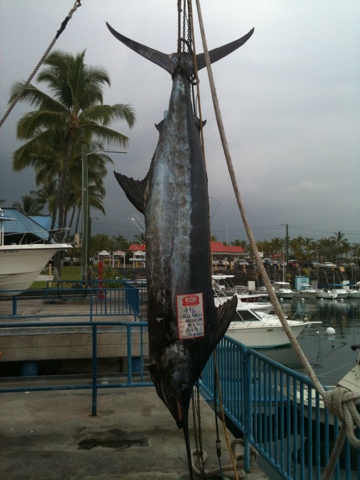
The Bite Me operation is impressive. A small fleet of charter boats in harbor, its own restaurant with its own dock and, conveniently, its own fish hoist.
“The first 50 pounds of catch goes to the customer,” says a less successful captain, a beer in one hand, a hose in the other on a boat now smelling strongly of bleach, “the rest goes to the restaurant.”
“I hooked a fish as big as that last week,” he continues. “We fought him for an hour and a half and he flipped the hook right here,” and he points the the boat’s stern.
“How old do you think that fish is?” I ask the skipper.
It seems a natural enough inquiry.
“I dunno,” he replies, “never raised one.” He laughs by way of suggesting that was the dumbest question he’d ever heard, and then gets to the nub of the matter. “Sure taste good though.”

Fishing boats in harbor outnumber sailboats twenty to one, and the only other active cruising boat here is directly ahead of Murre. She is Tao, Chris and Shawn aboard. From Oakland by way of Mexico and soon headed to New Zealand via the Cooks, Tonga, Samoa, and Fiji.
We joke that we have the state of Hawaii to ourselves. Cruisers who arrive here often depart as soon as possible, having seen but one island and its one marina. Admittedly island hopping in Hawaii presents unique challenges (see last post), anchorages are often exposed and rough, and official rules are not cruiser friendly (though the officials themselves are sweet as pie after a time). But rugged beauty there is in abundance, and we marvel at the islands’ bad reputation. Which is not to say we are disappointed. More catch for us.
Night Hopping to the Big Island
March 27
It wasn’t that the wind had come fair for a passage to the Big Island; this was simply the fairest it had been in days and days. Small craft advisories in all channels had been cancelled. Easterlies of 25 and 35 knots had given way to north easterlies of 20 with a promise to restrengthen by the weekend. I had plans to meet Joanna in Kona the first week of April–this could be my only shot.
During the day I secured the boat and then lay early in my bunk, wide-eyed and worried. The alarm wakes me at 0200. By 0300 I’ve made coffee, kitted up in boots and oilies, and we are underway, motoring below Diamond Head for the Kaiwi Channel to Lanai, Maui’s Fish Hook (the constellation Scorpius) our guide, bright and high. Wind in the channel comes on slowly but is 17 knots from the northeast by 0600, Murre close hauled at nearly five knots. By 0900 it is gusting 22 but the wind has veered more into the north as we come behind Molokai and so I can ease our single reefed main and jib. Still, the rail is under, water everywhere.
Around 0800 I see whale spouts and soon there are two dead ahead but five boat lengths off. Both disappear without sounding; Murre and I pass and we never see them again. Then at 0906, I am coming back on deck from breakfast and see a glossy black line in the water two boat lengths ahead. Before I can jump to the wheel a great fluke thrashes the ocean in front of the bowsprit and the whale dives, leaving a slick like that of a ships.

Passing Molokai in the Kaiwi Channel
An hour later the wind abruptly eases to 6 knots from the east, and we are motoring with sails up. I’ve made it through, I think. But the lull is brief. Dark water ahead and the flash of white caps. When we are hit it is wind 20 gusting 25 from the east, forcing us to motor-sail as close hauled as can be for the last six hours to Kaumalapa Harbor on Lanai’s south side, tiny, rock-bound, with wind shooting down the canyon from the east and then the north. But secure, quiet, welcome. Anchor down by 1630. 57 miles in 13 and a half hours.

Chopping up to Lanai
–

Lanai's Cliffy Backside
–

Rocky Promontory, South Lanai
We had fixed some leaks, but the weather finds others. On this crossing, water came in the port Dorade vent. We were on port tack and heeled heavily. The vent only drains to port, so filled with spray and overflowed into the cabin.
Lentils for dinner and I am asleep an hour after sundown.
At 0200 the alarm sounds again, and again, by 0300 we are in the offing, making for the lee of Maui under a brilliant sky, the cliffs of Lanai dark and tall like the walls of an ancient fortress, wind soft on the face like breath. We motor around the island. The red lights of the turbines on Maui’s western mountains and the glow of the small town down and to the right. Phosphorescence bubbles by, tiny suns are born, go super nova, and return to the void.
At 0640 the sun tops Haleakala and within moments there is wind on the nose at 15 knots. I try wearing a diving mask to keep the continuous waves of spray from my eyes, but the sun strikes the water on the mask surface full-on and is blinding, reducing visibility to nothing.
By 0800 wind veers northeast and we sail for an hour; then it dies. I motor past Molokini, and, as it is early, I turn to take a spin through the moorings, already full with the day’s dive boats. Something strange about the water dead ahead. “Sailboat Sailboat go OUT and AROUND the reef!” calls the radio. Hard to port. I miss the reef, but have lost my taste for a spin through the mooring field.
1030. Anchor down at Makena in sand at 17 feet. Calm. I swim in the coral garden for an hour then fall asleep on the bow, waking to an uneasy motion. A chop is building suggesting wind from the northwest, and Murre is exposed. By noon the wind has picked up to 10 knots, but I can see much more headed our way. I weigh and we move around Pu’u Ola’i Hill to Olenoa (“Big Beach”) just as white caps pour into Makena. Wind tears through the rigging all afternoon, but Pu’u Ola’i knocks down the chop and Murre rides easy.
I have lentils for dinner again, but they are not tasty. I am not hungry. By sundown I am in my bunk–alarm set for midnight. The infamous Alenuihaha Channel is next, our last barrier to the Big Island’s lee.
These are all night crossings–The Kauai Channel, The Kaiwi Channel, The Alenuihaha–for a reason. Trade winds sweeping across the vast ocean meet the high islands of Hawaii and funnel around. Wind that is a mean velocity of 15 knots on the ocean can increase in the channels to 25 knots and more as it squeezes through. But it is not the wind we worry about, it’s the waves that, in such tight quarters, grow high and steep and out of proportion to their cousins on the open water. Similar issues face the cruiser in the Sea of Cortez as wind funnels down from Nevada and Arizona and sweeps the narrow water between the Baja peninsula and Mexico, creating what locals call “Buffaloes” for the way breakers charge along in a heavy rushing stampede.

Windfield Chart of Hawaii's Channels (click to enlarge)
In Hawaii the worst is the Alenuihaha because it is between Maui’s Haleakala at 10,000 feet and the Big Island’s much taller Mauna Kea. Wind velocities here are pushed beyond measure. Breaking seas of 12 and 15 feet are not uncommon. One deep-sea tug captain reports a big growler took out his wheelhouse. Again, I lay in my bunk not sleeping. I decide in my worry that Alenuihaha is Hawaiian for “the great alligator she is laughing.” Ale (gator) Nui (great) haha (obvious). Nevermind that alligators don’t grow here.

The Alenuihaha Channel from space. The camera is facing southwest with the Big Island on the left, Maui, Lanai, Molokai to the right. Note the flow of trade winds into the channel as indicated by the funneling of cumulus clouds. Maui's Haleakala at 10,000 feet can be seen as well as the Mauna Kea crater on the Big Island at 14,000. Upalo Point juts out into the channel and Murre's destination, Kailua-Kona is the dark spot of coast directly above Mauna Kea.
And the day heightens the effect. The sun heats the land pulling air up, making the wind funnel the channels with even greater speeds. So we wait for the blanketing of night, and we hope. I have to remind myself there are no small craft advisories forecasted. I have to remind myself we have worked UP to Maui for a reason and that an attack from here means we should take the Alenuihaha on a broad reach. Still, I have already double reefed the main.
I wake before midnight without the alarm. Both groggy and tense. Boots, long pants, double sweater (in the tropics? Yes!), oilies. Coffee. A snack bar in each pocket. A litre of water tucked under the rail. We are in the offing within the hour. Zero wind. The white water that blew out Makena anchorage in early afternoon is gone. But the channel is something different. There will be wind there. There is always wind in the channel.
By 0100 it has come. We are passing the point and wind is 20 gusting 22 northeast. And the waves? I can’t see them. The moon set an hour ago. Be we are close reaching. Course 160 degrees true. Perfect. Easy now, but we are not quite out from behind big Maui.

What night sailing looks like...dark.
0200 and Murre is chopping along, keeping our course and racing at 6 to 6.5 knots. A little wet, but nothing to expectation. Heavy water over the top with a slam only twice. I make log entries from under the hood and note how luxurious it is to be dry and out of the wind. A grand night above: Mars is in Leo; Saturn in Virgo; Corvus points to the False Cross (I think). And Maui’s Fish Hook, our guide. So few constellations naturally look like the thing they represent. Orion, the Big Dipper, Maui’s Fish Hook–familiar friends.

Resting Behind the Hood
Wind increases by 0300. I go back to the wheel to take in more of the jib, but I lose the sheets. By the time I’ve rolled up the entire sail, they have knotted together in what looks to be a decorative braid three feet long and so Gordian I think I may have to cut the line. It takes fifteen minutes for the knot to unravel.
Speed same. Course same. The chart plotter sounds an alarm and shows a small cruise ship on an intercept, the Safari Explorer doing 9.5 knots. She passes, a wink on the horizon. I sit under the hood and find I am worrying about tsunami debris approaching the Canadian coastline, ahead of my projected return course later this year. A fishing trawler washed into the Japan sea a year ago is now derelict and drifting 150 miles off Queen Charlotte Sound. Earlier predictions suggested debris would not arrive till late in the year. I would just skate through. But now? Not.
0500. Wind up and down between 20 and 25 but northeast. Blessed northeast–it is making this a comfortable run. Keeping our course takes fiddling. I opt for easing the main or drawing it in from under the hood for fine adjustments. Quite a roar in the rigging. Dawn coming. A haze over Mauna Kea, the island a slate slab. And with first light, the waves. Which are small now. We are behind Upolu Point twenty-five miles to windward. It must already be knocking them down.
0630. Sunup over the Big Island. Maui still visible astern. Wind 25. We are fast. Murre rides easy.
An hour later wind has dropped to 10 knots from the east, and an hour after that it has vanished into thin air. We are still twenty miles from port and must motor. Now the island is completely obscured by vog (volcanic smog/fog). Upolu Point is gone. Moana Kea at 14,000 feet is gone. No island is visible until we are eight miles out and still we motor in a dead calm. An anti climactic end to an otherwise lovely crossing.
We glass into Honokohau Harbor, just up from the town of Kilua-Kona, at 1430. 62 miles in 14 and a half hours.

Spreading her Solar Wings at Hokolohau Harbor, Big Island
Mucking About in Honolulu
Murre departed Pokai Bay on March 18 for a short passage of but 25 miles to Honolulu. It was nothing to write home about. A lovely two hours of sailing on a broad reach below the lush canyons of Wainea followed by five hours of motoring dead into an easterly.

Cruising along the south side of Oahu
That knuckle of land where the coast turns from trending south to due east I call Ship Point after the tanker that seems ever to be moored there, two miles off, and requires going around. Here is where the wind came hard on the nose. It took two hours to approach and finally pass the motionless hulk against which waves crashed as if she were a stretch of long, black cliffy coast. A crewman on the bow wearing an orange jump suit sat back and watched and Murre rose and fell and threw water like a shaking dog. It would be impossible to describe the patience required to sit at the wheel and take spray in the face for five hours as one’s charge, not charging on so much as plunge diving, averages speeds easily outmatched by the tottering old.
Slowly the skyline of Honolulu came into focus; incrementaly slowly the buildings grew in stature. The expected lee of Diamond Head was no lee, and the wind only eased as we entered Ala Wai Harbor. As we entered our slip there was none.
Easterlies of some force kept us bottled in Honolulu for a week. And though I was eager to continue on to the Big Island, there are worse places to be bottled, especially when a small white lie told to the state marina people regarding Murre’s overall length resulted in our being assigned a smaller than appropriate slip there, with the further result being that we were forced to remain at the Waikiki Yacht Club. Here the bartender greeted me with “Welcome back. How was Kauai? G and T, right?”

Bishop Museum's Main Hall
But waiting was not wasted. I varnished the toe rail, recalked the leaking cuddy, and, after nearly wrecking it, managed to rebuilt the seized anchor windlass. By way of diversion I visited the Bishop Museum one day and the next discovered the Polynesian voyaging canoe, Hokule’a, floating beside her dry dock on Sand Island. Happily, it was a Sunday and she was covered with a busy volunteer crew. As I stood gawking a large shirtless Hawaiian man walked over to introduce himself. “You checking tings out, brah?” he began, smiling broadly. He was Kai, had sailed on the Hokule’a to Okinawa in 2009 and then to Palmyra Atoll near the equator some years later. “Hokule’a saved my life,” he said. “I was young, doing bad tings. Then I met Nainoa. He told me that it’s easier to know where you are going if you know where you have been. So I joined the Polynesian Voyaging Society. The Hokule’a is our heritage.”
There is general scholarly consensus that Hawaii was settled by Polynesian peoples who set forth from the Marquesas Islands around the time of Christ in large, twin hulled, voyaging canoes. The impetus for these voyages range from the related reasons of overpopulation, famine, and power struggles. But consensus stops there as one school of thought holds that Hawaii was discovered by trial and error (with the repeated loss of life this method implies) and the other that ancient Polynesians were excellent navigators and could transit the Pacific at will.

Hokulea circa 1975
In the early 1970s this latter group formed the Polynesian Voyaging Society to test their theory. A replica canoe, the Hokule’a, was built and a Hawaiian who could navigate in the old way was sought. But none existed. The art had been lost to Hawaiians. In fact, only one man in all of Polynesia was known to navigate by sea and stars alone. He was Mau Piailug (and here) from the Carolinian Island of Satawal. He was propositioned by the Society and agreed to the task, then brought to Honolulu where he learned the stars of this new area at the Bishop Museum planetarium.

Mau Piailug
Aboard Hokule’a he and crew departed from Hawaii for Tahiti on May 1, 1976 and arrived safely a month later, having sailed from one small spot of land to another over 2600 miles of open ocean. No navigational aids were used but stars, sea, wind and the occasional bird; no technology but that in Mau’s head.
Nainoa Thompson, a young Hawaiian crew member on that voyage, watched Mau with awe and vowed to return this ancient art to his people. He spent months in the Bishop Museum planetarium learning the night sky, memorizing hundreds of stars for the north/south transit. Then Mau returned to Hawaii to tutor young Nainoa on using these stars for position and course.

Nainoa Thompson
In 1980 Nainoa successfully navigated Hokule’a to Tahiti and back based on a system blending Mau’s techniques and that of his own devising.
Since then he has navigated Hokule’a over most of the Polynesian triangle and has taught many other Hawaiians the old method. He has become somewhat of a legend in Hawaii. Months ago I sat in a Super Cuts chair in Kauai and, conversation with me usually having but one trajectory, the young cosmetologist and I soon began to talk about Polynesian voyaging. “Have you heard of Nainoa Thompson?” asked the woman who had earlier admitted she’d never been off the island. “When I was a kid he would come to our class. We’d ask him how he pooped in an open boat. We were kids, right? That was our big question. He said you just jump in the water.” She laughed. “He’s very kind. And humble. Soft-spoken.”
He was soft-spoken, at least. Nainoa moved about the decks of Hokule’a the day I met Kai. He was slender. He moved slowly, with intent, giving instruction softly to one crew member, patting the next on the back. He was now mid-fifties and greying. Not the canoe’s captain but more senior, in charge of not just the boat but the project, the heritage.
The Hokule’a began to warp out for a practice sail and Kai jumped aboard. “Kai, I’d love to join. Do you need crew today?” I asked.
“Sure brah,” said Kai, still smiling. “On Tuesday and Thursday nights we meet here. We clean the boat, we varnish and make lines. Then in a few weeks you sail.”

Hokulea Today
–

Hokulea Detail
–

Hokulea Detail
–

Hokulea Detail
–

Hokulea Detail-warping off
–

Hokulea Detail
Kauai to Oahu with a note on groceries and baseball
A casual reading of current posts may suggest I am simultaneously in Saudi Arabia and Hawaii. So warns my wife. Knowing my gifts as she does, she flatly insists this is impossible. One time it so happened I reported I was at the Safeway at Market and Dubose when in fact I was at the Lucky on Masonic and Lyon. She had told me to go to the Safeway at Market and Dubose for the soy milk (light) and toasted squares of seaweed in a box (teriyaki) for her and the week’s coffee for me. When I called and said it wasn’t there she said, “Where are you?”
“At Safeway,” I said.
And she said, “No you’re not. Safeway has what I want.”
And I said, “OK.”
And she said, “What’s the sign say?”
And I said… Well, for a moment I said nothing. What did she mean by sign? I looked up and sure enough the sign above the vegetable section declared in big, friendly letters, “Lucky. Your Low Price Leader.”
So I said, “Lucky. Your Low Price Leader.”
And she said, “See. If you were at Safeway it would have read ‘Safeway. We have what Jo Jo wants.'”
So I went to Safeway, and it had what Jo Jo wanted. But the sign said something different.
Point being one of clarity. I’m in Hawaii now. Sadly, the Saudi trip is in the past, though I will continue to report on it in the coming weeks.
_____
We (Murre and I) are on the move again. Are anchored at Pokai Bay, South Oahu, to be specific. A cruise of the Hawaiian islands has commenced with a near-term goal of reaching Kona on the Big Island in the next week or so.
_____
March 14
2:15am. Departed Nawiliwili for a crossing of the Kauai Channel for Oahu. This was my only break between early week moderate to strong trades and forecasted late week strong trades. A lull. Grab it. Hawaii’s channels can be nasty places for a small boat.
I planned one long tack SE as close on the wind as could be born. Simple, in concept.
But I have not sailed for months now. In the boisterous seaway of a moonless night I kept fumbling the lines, missing my grab, tripping on stays. At the main mast I pulled hard at what I thought was a halyard, and the spinnaker pole came tumbling down on my head.
With sunup, winds NE and steady at 20 knots with prolonged gusts to 25. Steep, crashing chop. Murre straining under a too-heavy press of sail. A reefed jib and a reefed main. But this was necessary in order to power her nose out of the swell, I reasoned.
Murre complained anyway. Her bowsprit spent more time underwater than above it. The main cabin ports on starboard were constantly seeing blue. My new cuddy did a wonderful job of keeping water from coming in under the companionway hatch and its hood kept my head dry (I typically sit in the hatch while underway), but every time we took a big splasher over the top, all the water that landed on the hood funneled into my lap and then below. I’d built the spillway wrong–not directed far enough aft.
And such a jarring motion. Holding on below took all fours. I couldn’t cook, could barely bring myself to eat. I felt seasick for the first time since leaving San Francisco.
Murre could not hold her course. By mid channel we were six miles to lee of the mark. Then eight. By sundown we were abeam Pokai Bay, but ten miles below it. A man of courage would have kept sailing–he would have climbed to the island tack upon tack–but that same man would not have made port at all that night.
I started the engine and for another three hours we motored at three and four knots into the wind, engine lugging and smoking, to my great concern.
Anchor down at 8:30pm. I went right to sleep. The passage of 72 miles had taken 18 hours.
And woke with a splitting headache. I’d had no coffee the day before.
But a blissful dawn at Pokai (and a cup of coffee) erased my head’s concern. I spent the sunny morning overhauling the seized anchor windlass and the sunny afternoon in the clear water cleaning Murre’s bum. The engine lugging, I found, was due to Kauai barnacles that had encrusted the propeller. Now scraped away.
In the evening I tuned the radio to a local college baseball game. A no hit yawner left the announcer extolling the virtues of the pitchers, the same virtues, inning after inning.
Then in the sixth the UCLA Dons scored on a base hit followed by a double play ball that the University of Hawaii Rainbows short stop threw into the stands.
When the ‘Bows came to bat, they answered with a lead-off base hit. Two perfect bunts, both botched by the pitcher, loaded the bases and a bobbled then dropped sac fly sent two men home.
The announcer for the ‘Bows, suddenly awake, exclaimed, “Oh my, this game can turn on you like a dime!”
I’ve heard tell of sportscaster mixed metaphors but had never fished one fresh from the sea, all shiny and still beating. The crowd continued to make its noise; the sportscaster continued to exclaim. It seemed only I had caught this small prize.
A dinner of pasta, red wine, and a book, Ben Finney’s SAILING IN THE WAKE OF THE ANCESTORS, ended a perfect day.
end
Kauai Abnormal
Thursday, March 8
Aboard Murre, Nawiliwili Harbor
2am. I wake to wind and heavy rain. Too bad. I’ve not put the boat cover back after the day’s work. Then lightning. Not close. Often no thunder. But it’s like paparazzi flashes. I count seconds–one-and-two-and-three-and–and see white light on every upbeat at least. Sometimes it comes in bursts that defy counting. I dash on deck to spread the cover. Rushing to finish before the lightning nears. Breathing heavily though the work is not strenuous. Thinking how dumb it is to be on deck, naked, in torrential rain…in a lightning storm. I wear rubber flip-flops for protection. During last week’s storm two boats on this finger were hit. A strike blew the through-hull out of one boat. Six inches of water inside before the owner, lucky to be aboard, could jump from his bunk. I saw him on the dock today. He looked like a man who’d seen god and was not too happy about it. How can a weather cell contain so much energy? It’s raining lightning.
—
Bridges out or closed, landslides on north shore roads, 36 inches of rain in Hanalei this week. And in the days following, winds to 40 knots in the channels. Still, the cruise ships come and go as if all is usual.

Turn off at the Kapa'a bypass road. Photo courtesy Dinah Chao.
***
Today, from Starbucks.
Mixed cloud and decreasing trades from the NE. But only midweek. By Thursday, expect more trade wind advisories. Yesterday was dry, all day, first time in memory. This is my window. Will attempt departure tonight.
A Harley Rally in “Good ‘Ole KSA”

February 2, 2012
“Why would I post pictures of a Harley Davidson Rally?” I asked my sister. “Who’d be interested in that?”
“Brother,” she said, “It’s a Harley Rally in Saudi.”
—
How the iconic motorcycle had become embedded in American culture I could half understand. Big as Texas, Vegas-shiny, loud like New York and LA-cool. The Cadillac of motorcycles. As American as …
Old fashioned and now a non-sequitur is the 1970s car-company slogan “Baseball, hot dogs, apple pie, and Chevrolet / They go together in the good ‘Ole USA.”. But swap Harley for Chevrolet and the rhyme becomes free verse, the jingle fresh and true. What’s “Ole” is new again. Fitting is the fact that Harley is a company re-invented, pulled up by its own bootstraps. Chevy was recently bailed-out.

Iconic Harley Chopper at Dhahran Rally
But why should Americans alone enjoy their wild west romance? “Live to Ride / Ride to Live” has broad appeal, after all. The horse made our country as, until recently, the camel made theirs. They have their own wide open, untamed spaces, love of a well-built machine on which to roam. Why shouldn’t a romance for the past find truck here? Why shouldn’t they also find this fun?

A Camel within the Harley Logo in Saudi
The day of this much-anticipated event dawned slowly. For weeks posters in Dhahran’s public spaces had invited all to join and to sign up early. Participation required a special-issue identification card. Which needed a current passport photo. Which needed processing. Which needed time.
Dawn came slowly because days earlier a dust storm had kicked up in Jeddah and was blowing all the way across the country. The Arab News reported traffic jams, collisions, falling trees in that city. School was suspended. Government urged everyone to stay home.

Makkah Gate near Shumaisi is hardly visible as motorists ride through the dust storm. (Arab News photo by Mujib Hussain)
The storm reached Riyadh about the time that city’s Harley chapter began its convoy toward the Dhahran event. They surfed it across country to the Gulf.
“Should we go?” asked Bruce, searching the window for any sign of sun. “We try not to ride in this weather…makes the lungs hurt.”
But the dawn of this much-anticipated event was too much anticipated to miss.
This is the Middle East a Westerner might not expect–communal, light-hearted, playful–even in adverse conditions.
Click here to see all photos of the Dhahran Harley Rally.
Thank you to Val and Lavonna for the photography and to everyone for such a fun event. A special thanks to Lavonna for letting me borrow her bike, for a month.
Back to Kauai Normal

From Saudi to San Francisco for a few days with the wife. Lovely to be with her at home. Lovely being home, except for the overcast and the cold. A year in the tropics had convinced my metabolism that its requirements were permanently relaxed, and being so suddenly called to attention, it reacted with palpable resentment. I shivered even with the heaters blasting.
Other things had changed while I was away. The stylish furniture in our livingroom was entirely new to me as was the flat screen TV big as a billiard table. The bookshelf on my side of the bed, the one filled exclusively with my books, was missing. My bedside lamp had abandoned my side of the bed and now stood smugly beside the new couch, and Joanna’s things covered my small desk, her protests that she had “just tidied it” notwithstanding.
“Remember, we were broken into while you were away…” offered Joanna by way of explaining the new arrangement.
“…right, and the thieves took my old paperbacks and left you a new TV,” I said.
“Not exaclty. But see, you still have the big red chair,” she said as she flopped into it.
“Where should I put my bag?”
“Not in your closet. No more room.”
Admittedly, the apartment had never had much sympathy for my belongings, Joanna’s being so much nicer, but I began to feel that in the past year the two had conspired to move me out.
“Any mail for me?” I asked.
“Only a jury summons for October,” she said.
And then, “If you are coming home, we might need a bigger house.”
If?
—
Joanna accompanied me back to Kauai where, for a long weekend, we fell into our usual routine. Hike, swim, shave ice. Lay on the beach, swim, shave ice. Go for a run, sushi for lunch, shave ice.
The frangipani-scented trades blew softly out of a blue sky and held up cottony clouds as if nothing could be easier. This must be what was imagined when the first people imagined heaven, I thought, even if the island’s wild boars do not lie peacefully with the endangered honey creepers, even if they still tend to eat things they shouldn’t.
“What do you want to do today?” asked Jo.
“Hold hands,” I replied.
“We did that yesterday.”
“Hike … and hold hands?”

Waimea Overlook
–

A Ritual Stop
—
After Joanna returned home, my friend Jim arrived. For ten days we were on the go in a way I had not experienced since my first few trips to Kauai.
We–
-Hiked The Sleeping Giant and Kuilau Trail.
-Toured the Haraguchi Rice Mill and Taro Farm in Hanalei.

View of Taro Fields in Hanalei Valley
-Hiked the Okolehau Trail in search of views, which we found, and mud and wild boars, which were accepted as part of the experience.
-Walked the McBryde Gardens in Poipu and later took a guide for the Limahuli Garden’s collection of canoe plants.
-Found the Makauwahi Cave which is the focus of David A Burney’s book Back to the Future in the Caves of Kauai
–Made Red Dirt Shirts in Nansy’s kitchen with her full knowledge and consent, tepid consent to be sure. Not this recipe, but better than Mike Rowe’s.

First Dunking into the Cooking Mud
–

Success. Wait, is Nansy home yet?!
-Observed the Laysan’s Albatross, Great Frigate, Red Footed Boobie, White Tailed Tropic Bird at Kilauea Lighthouse wildlife preserve. While Humpback whales breached in the distance.

Kilauea Point and Light
-Rented a cabin in the mountains of Kokee State Park and hiked the great Waimea Canyon to Waipo’o Falls; later we entered the Alakai Swamp in search of native birds (of which more here).

Waipo'o Falls
-Hiked the Kalalau Trail along the Na Pali Coast.

The Na Pali Coast of Cliffs
Each evening we returned to my in-laws home in Kapaa town to talk story over Jim’s fine wines. It helps to have a friend who is a wine maker.
I slept on the lanai because I finally had an excuse to, Jim having taken my spot in the guest room.
Then the rains came. They had begun that last day on the Kalalau Trail, a steady drizzle with thunder somewhere beyond the far mountains so muffled I mistook it for waves crashing on the cliffs below. But after midnight the winds shut down and the lightning started in earnest. Pop, pop, pop–the low cloud lit uniformly like a giant flash bulb. From my bunk I tried to close my eyes against the bright but found they were already shut. Then a few breaths before the rumble, soft at first like cannon fire out at sea; it rolled on and on getting louder and louder until it was like the exploding of the near mountain. Any moment I expected the house to be crushed by falling boulders. Sometimes the lightning was close and then there was no delay. The flash and boom were apocalyptic. I flinched.
And the rain poured. It gushed from the sky as if someone had upended the ocean.
I didn’t start counting till three in the morning. Hours on end lightning had been flashing once every twenty seconds or so, I found. By five I could count up to 45 seconds before the next strike. I thought the cell, a mushroom cloud bigger than the island, must be receding back into the ocean that birthed it. Then lightning would crack in machine-gun clusters like a fireworks finale. And after a pause, it would begin again its regular rythm. The charged sky was inexhaustible.
Just before dawn wind came off the mountains, and my place under the eve was no longer protected. A sprinkle at first, and I reacted by curling under the blanket. Then one gust and I was drenched–blanket, sheet, pillow, futon mattress, me–all soaked through. On this day I was the first to rise and make coffee for the house.
Lightning, thunder and rain continued all day and into the evening. Any waterfall that could fall fell. Rivers ran the color of carob and carried great rafts of dead wood from the hills. A real Kona Storm.
")
Composite Radar Image of Cell over Kauai (the square in the middle). Note Oahu off to the right, dry.
Mount Waialeale is Kauai’s highest peak and is reputed to be one of the world’s wettest spots. There are no roads to the top. Trails are almost immediately jungled over and always slick. The ascent is treacherous, and you won’t find it in the guide books. Thus the first USGS rain gauge placed at the summit in the early 1900s was meant to measure annual rainfall. But the gauge held a mere 300 inches of rain and upon inspection was found to be full before its time. The next gauge held 900 inches. It found that rainfall atop Waialeale averages between 389 and 423 inches a year.

First Rain Gauge
On the day of this Kona Storm, Waialeale received over six inches of rain. The town of Anahola over eight. Lihue’s rainfall was an all time record.

Nawiliwili Harbor
I’ve moved back aboard the boat. A few projects need doing before Murre and I launch another run through the islands. But our Kona continues. Two nights ago lightning lit up Nawiliwili and knocked out the harbor lights. I gingerly trod the cabin in flip-flops, expecting any moment to hear the splitting of Murre’s mast. And the next day it rained like Noah’s curse. And now and still.

Kona Rains at Nawiliwili as seen from Murre's Cockpit
Dhahran, First Impressions

Saudi Aramco, Dhahran
It may be a truism of travel that at base one place looks much like another. When I first landed in Kona, Hawaii years ago, I was disappointed to find the topography so similar to my native California. Shouldn’t it have been utterly different? Afterall, it was over 2000 miles away. That epiphany lead to others. The cloud soaked hills of Marin are like wandering similar hills in Scotland. Mexico City has the flavor of an ancient, future Los Angeles, Los Angeles a decayed Tokyo. The Farasan Banks of the Red Sea froth white with waves like those that crash on the Great Barrier Reef. Carl Sagan exclaimed at his first view of a new land, “This was not an alien world, I thought, I knew places like it in Colorado and Arizona and Nevada.” He was referring to Mars.* So I should have known.
Still, there was some surprise at finding that my sister’s neighborhood inside Dhahran’s mostly expat compound could have been in the suburbs of Phoenix or San Diego. Streets were regularly laid out, tree-lined, sidewalks wide and free of cracks. Every several blocks was a small park for the children or a duck pond and fountain. The neatly manicured golf course was ringed by a paved walking track. There was a heritage museum dedicated to Aramco history, a large library, two fine restaurants, a commissary jammed with western goods, a gymnasium with an olympic sized-pool, even a bowling alley. Two on-camp radio stations played American pop and American country music, respectively. Here, and nowhere else in Saudi, women of any nationality could drive. Western dress was the norm.
It was comfortable. It was like being at home. It was designed that way.

Green Oasis of Dhahran Camp from a Nearby Hill

Charming Houses of Dhahran

My Sister's Corner
–

At the Party

An Afternoon Farmer's Market

Gas is less than $1 a gallon

Bruce and Lavonna out for a Harley Ride of the Hood

Prosperity Well

Prosperity Well--where it all began for Saudi, circa 1933

My First Day--identification freshly pressed

Passing the Main Gate
Muslim women often wore their black abayas on afternoon walks, even jogging, and contrasted sharply with others in their running shorts and tank tops. Groups of groundsmen from the sub-continent, all in yellow jump suits, roamed freely and napped in the shade for long periods after frenzied bursts of grass cutting or weed pulling. Their approach might flush a Hoopoe digging for insects in the lawn or a Bulbul or a Myna. Small mosques dotted the compound, following the age-old rule that all who wished should be within easy walk of a place to pray. The call rang out frequently, and then the groundsmen would wash hands and feet at the closest spigot, lay out their headscarves on the lawn and kneel, facing Mecca.
Saudi fighter jets roared low overhead any day except Friday, banking left and flashing the green ensign–a single simitar below the famous remark in Arabic script, “There is no god but God, and Mohamed is his messenger”. “The air base just beyond that fence is in high gear now,” said a neighbor pointing to a long runway obscured only by haze. “They’ve been at it constantly for weeks, but they bank left, always left. I hope that turns out to be the correct maneuver when the time comes.”

Saudi Fighter Jet
That these essential differences were folded into such a familiar framework made my head spin.
____
“Oh, you are so lucky!” was often repeated at my sister’s lavish dinner party.
Her social circle of expats included nurses, dental hygenists, accountants, grade school teachers, administrators, airplane mechanics, auditors, geologists, and engineers. A more diverse group under one roof I had never met, and all were handy at conversation, quick to laugh, and utterly welcoming. All went out of their way to congratulate me on the next trip. “You are going to dive the Farasan Banks? Almost no one goes there–you lucky man!
____
*Cosmos, Carl Sagan, Random House, 1980, Location 2178.
A Desert Interlude, Getting to Saudi Arabia

January 11, 2012
Saudi Arabia is effectively closed to westerners. Though as many as 100,000 expats–mostly from the US, UK, and Ireland–are employed in the various camps of Saudi Aramco, the national oil company, western tourism is unheard of. Even when one has the advantage of a sponsor, a sister stationed in the eastern province town of Dhahran these last ten years and more, the acquisition of a visa can be tricky. Add to this the short vacation times afforded the typical working American–Saudi is 170 degrees of longitude east of my home in San Francisco; recovery from jet lag would take a week–and the general unrest in the region as portrayed in western media, and one might sympathize with my delayed visit.
But with winter booming in the north Pacific and Murre tucked away safely in Nawiliwili, there was no better time.
“Your first step is to call our Houston office about a visa,” said my sister when I phoned to arrange travel. “Speak to Mr. Mahomet. I can’t do this for you. He’ll talk only to you. You’ll need to send him your passport. And be ready.”
Ready?
“You have not sent your passport I hope, “said a heavy voice when I rang Houston and stated my purpose.
“I have not,” I replied. “That’s why I’m calling.”
“You have a brother in Saudi?” asked Mr. Mahomet.
“No.”
“A father?”
“No.”
“You cannot visit unless you have family in the country to sponsor you,” he said.
“I have a sister who works in Dhahran.”
“A sister…hmm…but she is female…?”
“As I recall…”
“This may be difficult. Is she married to her husband?”
“Yes,” I said, momentarily unsure.
“And are you married?”
“Yes,” I said, and then quickly, “to my wife.”
“And your brother works at Saudi Aramco?”
“I don’t have a brother.”
“So your sister is not married to your brother?
“No, but…”
“Oh, this is not good,” said Mr. Mahomet sharply. ” As I said, the embassy will not extend a visa unless you have family in the country.”
“Let me clarify,” I said. “My sister and her husband–my brother-in-law–are both married, married to each other, still married, and both work for your company.”
“Ah yes, but do they live in the Kingdom of Saudi Arabia? Aramco is a global company, you know. For example, I am from Jeddah, but I work in our Houston office, this is in Texas, and we also have offices in New Delhi, Shanghai, The Hague…”
“Yes yes. They both live in Dhahran.”
“And you are married?”
“Yes,” I said, ” to my wife.”
“And it’s your wife’s brother who is married to your sister?”
“Nope. My wife’s only related to me. Not by blood, mind you, she’s not my sister or even a cousin or anything like that…”
“Cousin! Now you are confusing matters,” said Mr. Mahomet.
“… but I mean my wife has no family in Saudi. My wife’s really not in this. She’s not going with me. It’s just my family in Saudi.
“Your brother and sister.”
“No.”
“Good,” said Mr. Mahomet after a pause, “here’s how we’ll proceed…do you have a pen? You’ll need to take notes…”
In addition to my passport, Mr. Mahomet would need to prove my existence and my relationships with a copy of my birth certificate, my marriage licence, a copy of my sister’s birth certificate and that of her husband, their marriage license and the their work visas.
“That’s quite a list,” I said, gasping.
“Not done,” said Mr. Mahomet. “I will fax over a three page application that must be completed entirely. It must be sent in with the above and along with two additional, current passport-type photos, not large, but passport size. If you look different now than when the original passport photo was taken, that needs to be explained in a note appended to the photos. Please sign and date the note.”
“I need to explain to you why I now have a beard as long as Abraham’s?” I asked.
Mr. Mahomet did not laugh. “Now,” he said, “I need all those documents, in that order, overnighted to my office in one package. Do not send things separately–they will get lost (Mr. Mahomet did not say by whom, but I had a hunch). It would be best if they arrived before Friday.”
“And how long before I get the visa?” I asked.
“Well,” he said, “we must wait for approval first. Maybe one month. Maybe two. Many things must be checked. Not long.”

I deplaned in Frankfurt in the gray of dawn, heavy with the fud of a New York red-eye and craving to commence my six-hour layover with an espresso and a croissant. With some surprise I observed that my much-anticipated first experience of northern Europeans within their own boarders would be a group of white-shirted German businessmen crowding the airport bar, heaving up yellow ale from tall glass steins, and wolfing red sausages whose rich odor had penetrated even the jetway. From such a breakfast, I wondered, comes the precision of German engineering? “It is zee lunch,” stated the bar tender when I asked about a poached egg and toast. I had been mistaken about the time–the quality of morning light being the brightest a high-latitude winter can produce.
Night was full when my Lufthansa flight made its bee-line for Dhahran. On the TV monitor our virtual plane passed over Turkey and Cypress before jogging right to avoid troubled Syria 39,000 feet below; then a straight southeast course was resumed, and we passed quietly over the vast, black reaches of empty Arabia. The attendant had brought dinner accompanied by generous pours of red wine, but as we crossed into Saudi air space, dry as a desert by religious decree, our glasses were retrieved and a pad lock clicked over the liquor cart. Next a customs form was distributed which contained, along with the usual requests for information, a box for my mother’s maiden name and my religion . These had featured prominently on the visa application completed months before, but that form had also required I divulge my blood type, my university and GPA–anemic, slacker-atheists of a certain family line were unwelcome, would at least be watched closely.
Stamped at the head of the customs form were bright red letters that resolved into the sentence, DEATH TO DRUG TRAFFICKERS, and served to remind that my country of intent was not of the usual sort. I am not a drug trafficker; I am not even a hobbyist, but as we touched down at King Fahd International Airport, my mind raced through the bag I’d checked and wondered if a generous supply of aspirin or mouthwash would damn the likes of an anemic slacker atheist.
Midnight and the airport was quiet. Its grand hallways, plushly carpeted and doors of gold, had the air of an old, abandoned casino. But instead of slot machines, here and there, prayer nooks were cordoned off. At the customs room, uniformed young men huddled, talking softly over their rifles as the Germans and I formed one long, neat line. We waited in silence. Our flight’s only female, a mother with her husband and two children, excused herself to use the toilet and returned in a full abaya. A Saudi couple, both in traditional garb, entered and walked directly to the head of the line. They were waved through by the officer-in-charge without so much as a second glance. He appeared to be in his late twenties; the officer manning the customs booth was even younger. The line crawled.
Then with a whoosh the room filled with a hundred short, dark men in pastel tunics. Another plane had landed. “Laborers from Pakistan,” said my neighbor, “they do all the work around here.” The men wore heavy coats against the cold (70*) and black dress shoes. Suddenly the officer-in-charge came alive. He barked orders and another booth opened. He barked again, and the tuniced men moved haltingly to form two lines. He barked, and the lines attempted, with poor results, to become orderly. He waved a customs form above his head and the men, realizing none had it, abandoned their lines and moved bodily off to a corner desk. Forms fluttered into the group, and the men gathered into large knots, sharing in turn the three pens they had brought with them.
My opportunity came at last, and I handed my papers to an officer whose face was more fuzz than whisker. He did not look up, but talked with the inflated authority of youth into the headpiece of one cell phone while he punched texts into another. He nodded toward a camera and my picture was taken. He motioned, palm down, at the glass desktop where I put both hands and each digit was recorded by a green light three times. He checked his computer screen. Then he leaned back casually cross-legged to talk and text for several minutes. The screen beeped. He leaned forward without coming out of his relaxed posture, stamped my passport with the hand not texting and I was through. He had not said a word to me.
“DEATH TO DRUG TRAFFICKERS…”, I repeated as my luggage was lifted from the X-ray belt by yet another boy-officer whose only concern was to double with laughter at an obscure joke told by his partner. My bag and I passed without notice to the main gate, beyond which the press of Pakistani men awaiting their companions formed a narrow, undulating gauntlet at the end of which my smiling sister in her abaya and her husband in a yellow polo shirt stood out in absurd, welcome relief.

A Desert Interlude
- Getting to Saudi Arabia
- Dhow Diving the Red Sea (coming soon…)
- Riot Free Bahrain (coming soon…)
- A Goat Grab in Hofuf (coming soon…)
- Avoiding Arrest in Madain Saleh (coming soon…)

“Did you drown?…”
“Has the story ended? Did you sink the boat? Did you drown? ” wrote a concerned friend recently.*
And no wonder.
After almost daily posts to this blog for months, on coming ashore in Kauai I just stopped. Every thing changed. I moved in with my in-laws and spent a month in paradise on nothing but boat repair. I flew home to California and Texas for the holidays. Then there was the month in Saudi Arabia, a storm on the Red Sea and a brush with the law in Al-Ula. It was a heady time. I couldn’t keep up.
“You should make sure your audience is with you,” scolded a relative. Far be it from me to mention that “my audience” is mostly relatives–my mother, my sister and her geologist friend, one aunt in Canada and another in Orville, a few cousins, a friend and his mom–none of whom, save the geologist, have ever needed this blog to know my whereabouts.
But point taken. After all, I’m the one who started this.
So, after two months away, tomorrow I return to Kauai and Murre.
_____
*Should I respond to that email?
What Happened Next
November 8 through December 11
The disappointment of finding myself alone in a familiar harbor quickly evaporated. Peter and Nansy arrived before I’d switched off the engine, Nansy carrying a Ti leaf lei and Peter a broad smile and a handshake. That they had not met me earlier was my fault, I now recalled. Predicting the transit time of a small, wind-driven ship is futile, so I’d promised to alert them by phone as we made landfall. But Murre’s jockeying with a cruise ship at the harbor entrance distracted me, and I had failed to keep my part of the bargain.
Greetings were immediately followed by breakfast at a local restaurant where stacks of scented pancakes, eggs and bacon and endless hot coffee erased any memory of missed expectations. The sun shone, and a warm wind smelling of flowers ruffled the palms. I was on the dry land of an island I called home. I couldn’t stop smiling.
“Our house is yours–stay with us as long as you like,” they had said, and I wonder now if they later regretted such an open invitation. Because I moved right in, digging deep into the luxury of a real bed with soft, clean sheets, hot showers that required nothing more than the opening of a faucet, and home cooked meals, rich soups with fresh breads and brie and pickled herrings marinated in dill as accompaniment (the latter reflecting Nansy’s Norwegian heritage). From their lanai I could gaze out to the south and the ocean I’d just crossed; to the west was the bold line of mountains above Nawiliwili under which Murre relaxed in her berth, and to the north that range whose cloud covered peak, Mt. Waialeale, I knew to be the wettest place on earth. It was delicious. I stayed a month.

Peter and Nansy's home on a hill

With a view toward the ocean
By design it was a busy month. After so long on the go and under the hot tropical sun, Murre was the worse for wear. Her toe rail varnish, entirely neglected since leaving San Francisco, had baked or blown off ; the paint of her coach roof crackled and curled; the beating mainsail and its batton pulled paint off the mast in chunks, and a year of rock and beach landings had worn down the dinghy to bare wood. During the passage to Hawaii, two of the five solar panels had ceased to function; the bracket holding the engine’s oil filter in place snapped, and deck leaks had soaked many of the cabin’s cushions, which now smelled of mildew. Maybe most importantly, weather on this leg north emphasized the need to protect the cockpit hatch from breaking waves. The list went on and on…

The varnish had baked or blown off
__________

Coach roof stripped and patched
Luckily the welcome of my in-laws included the offer of power tools and their proper, open-air shop. Peter is a sailor and a boat builder in his own right. Years ago, Nansy and he constructed a river barge of forty feet outside their home on the Deben near Woodbridge, England. Here a gleaming but empty black, steel hull gave rise, as if by magic, to decks of varnished teak and an elaborate interior designed for entertaining, as if by magic because while these two were building this boat on the hard, they were also rebuilding the house it sat next to. This was before they retired. Once completed, the barge became Albertine, and on it they cruised the canals of France until there were none they hadn’t seen. Kauai’s waters are no place for a barge. So when they moved to the islands, Peter switched his focus to the traditional craft of the tropical Pacific. In his shop was a twenty-five foot proa nearing completion.

Peter's proa in build
The shop began to look like Murre had also moved in. The cushions for steam cleaning, their slats for painting were scattered haphazardly about. The dinghy and her oars pushed the car into the drive, and here they were sanded down, reglassed and brightened with fresh gloss. The storm windows, knocked uncleverly from plexiglass at the dock in La Paz, were trimmed and neatened. As to the cockpit hatch covering, I was of several minds, but consultations with my two hosts landed us on a small, tough cuddy with a canvas hood, which soon began to take shape from a single sheet of plywood.

The cuddy takes shape
My previous work on Murre was, I liked to think, extensive and well executed–a cockpit rebuilt, a length of deck relaid, a bulkhead removed and renewed. But all this work was confined to replacing things that existed. The old was the pattern for the new and so my imagination had remained mostly untaxed. The cuddy design, however, needed inventing from thin air, and I was frequently at a loss how to proceed. As I stood befuddled over the construction table, I’d often find that Peter had softly sidled up. “Yes,” he would say, “I can see where you are going with this. The top will be nicely strengthened with the epoxy fillet and that extra rib,” neither of which I had yet contemplated.
We rose early each morning and gathered, coffee cups steaming, on the east lanai to chatter softly about the coming day and to watch the sun rise. Once it was so clear we could see the hump of Oahu above a sharp, slate-gray horizon, but usually a sweet haze prevented seeing such distance, or towering cumulus filled the ocean and required the sun fight its way through. Trees along the near bank also obscured its rise, and often Nansy talked about which should be cleared in order to improve the view.

Peter at his garden
Then, before breakfast, we would dash to our tasks, I to the shop and Peter to his garden, or they two would attack the offending arbors before the day got too hot for hard work. Afternoons were reserved for books and napping, evenings for parties. Time flew.

Out to dinner with Peter and Nansy

The basic idea was to build a small cover over the companionway hatch with a hood that would allow me to sit under it, dry in all weathers.

First fitting to the boat. Would it work at all?

The hoops that would support the hood were made of several layers of 1/4" ply cut to into 1 1/2" wide strips and laminated into their correct shape around a frame of shaped 2 x 4s.

Once knocked up and hoops built, a second fitting to the boat, the purpose of which was to get right the height. I sat under it to make sure before cutting the top and hoops to final length.

Back at the shop, tabbing in the hoop base.

Detail of hoop attachment point.

Detail of hoop attach point.
Cuddy built and ready for paint.

Painted. Unsure, the car keeps its distance.

One last test to ensure I could sit comfortably below the hood before having the canvas made in town.

Canvas installed and cuddy complete.

Final detail of hoop hinge. Note spacers to allow for bagging of canvas when the hood is down.

The cuddy creates a small but "complete" protection from wind and waves.
On the Move–Honolulu to Kauai
November 10
Once through the breakwater and into the Ala Wai basin, Murre was directed to the Waikiki Yacht Club instead of the municipal marina, which was accepting no more “transients” (Hawaii’s official name for the cruising lot) until after President Obama’s mid-month visit. What possible connection there could be between the arrival of a small yacht and that of a world leader went obstinately unexplained, and only later did I learn that the Ala Wai Harbor Master was famous for closing his marina to transients at every possible opportunity. Thankfully his spite had not infected the Yacht Club whose port captain gave Murre a luxuriously long end-tie and offered to help with the lines. The ladies at the office were equally gracious as they accepted the fee for the slip, the fee for the electricity, the fee for the pool and the showers. And I was allowed access to the bar and restaurant as if I were a regular member, except that I was made to pay my check on the spot. Past the club library, down the hall and by cases of trophies was the club’s private entrance. And just beyond, center-city Honolulu.

Honolulu from atop Diamond Head
The charms of a city open only to those who come in the company of money. While its sidewalks can usually be negotiated without a toll, they quickly lead into temptation. Glittering store windows, the aroma and amiable bustle of restaurants, the bright lights of movie theaters all tug at the wayfarer’s unguarded pockets, and even the aloof museum requires a contribution before unveiling its mystery. A walk in the woods may be free, but a city is pay-as-you-go.
And in a city the vulnerable sailor, so long unable to spend his coin, is immediately adrift. That the smell of coffee-house brew is far more attractive than his own pot seems perfectly natural, as is the fact that ship-board staples are suddenly but leather compared to the offerings that sizzle in a steak house kitchen. A baseball game can be heard at no cost from the radio aboard, but baseball on the large television of a nearby pub and with cheering companions is what he longs for. Inexplicably he finds he is buying a round. He is happy. Everyone is happy.
Honolulu is big and built for fun. It fills the low plane from water to mountain with highrises whose ground floors are full of shops of every sort and whose doors stream with tourists. Tourists fill the street and gather in hordes at the cross walks–American and Japanese mostly, though there are representatives from distant Europe and China. While waiting at an intersection, the rare working man in his dark suit is pressed on all sides by vacationers and the occasional bare-chested, bare-footed surfer and board. By sunrise the waves below Diamond Head are dotted with surfers and soon after the beach fills with bathers–the hotels disgorge their chaise lounges; umbrellas pop open like daisies; dangling tags reveal their hourly rate. Large day-boats glide over the horizon offering cruises to famous swim spots, but few want to leave the beach, and the boat captains sit in the sand playing their Ukuleles for a tip to pass the hours. Surfboards can be rented and lessons received. If you have failed to bring your snorkel gear, that too can be had for a nominal fee. Drinks are served. Here, where it is perpetual summer, the city is always open and ready; enjoyment is available at every turn; payments begin at once.
To Jack Tar, whose pockets piracy had topped with gold, the expenses of a city were at least briefly supportable. But only seawater had flowed into my pockets for a year or more, and I was not so flush with the city’s excitement that I couldn’t hear the urgent whispers of poverty.

Joanna Hiking Oahu Mountains
Fortunately, the weekend after landing in Honolulu this particular innocent was rescued by a Good Samaritan in the guise of his wife, who is accustomed to a city’s bazaar and has a knack for a deal. The Surfrider Hotel room she had booked for the two of us magically, inexplicably became free; for no apparent reason except her presence, the Budget car was upgraded to a luxury class; and at the Pearl Harbor Museum, the docent handed us complimentary passes. Being of the city, my wife is no longer gobsmacked by the glitter and can walk by a row of shops without becoming a berserker. I held her hand tightly as we passed the unlikely fortresses of Gucci, Prada, Hermes (what these stores sell I do not know) on our way to a breakfast at IHOP. Later we hiked the mountains and drove the entire island without spending a dime. But Joanna could not guard me forever. On Monday she returned to the States, and I was forced to plan my escape from Honolulu alone. For this difficult task I retired to the bar of the club where Tom was already in the habit of handing me a Gin and Tonic before I was well and truly seated. Maybe I’ll leave tomorrow, I thought. Maybe.
We motored down the Ala Wai Channel on November 6th headed for Pokai Bay, a tiny, rock-wall harbor near the small town of Wainea, chosen because of its reputation for being a calm anchorage and because it put us within a single night’s sail of Kauai. Even from two miles out, the Honolulu skyline seemed to go on forever. An hour later jets on final approach dropped their wheels right above Murre’s mast. Barbers Point and its refinery loomed ahead and here a tanker was moored to a bright yellow platforms far offshore in the brisk easterlies, swinging on a single line like a dirigible as its ebony cargo was pumped through floating pipes to distant tanks. Even more than the island below it, this ship, I thought, is what keeps the city afloat. Once around Barbers, the island’s terrain dried up. The mountains became dead grass and bare rock. We pulled into Pokai an hour before sunset and dropped anchor in ten feet of water behind the dilapidated sea wall, battered by the last hurricane and never repaired.

Pokai Bay and the Mountains of Northwest Oahu
Next morning I rowed ashore to explore the town and quickly found that the neat bungalows along the beach belonged to the Army and were on a large military compound as now was I. When I asked a young woman leaving one of the bungalows for the walking path to the exit, I received a strange look. How could such a disheveled, heavily bearded man have gotten into an Army compound in the first place, and should she let him out? My explanations did not resonate, and the woman reluctantly pointed to a gate at the end of the sidewalk. “But it’s locked,” she said flatly. I was still plumbing the depths of my gratitude for the appropriate response when she continued, “Don’t you have a car?” I pointed to Murre, bobbing jauntily in the near bay, and reiterated the technicalities of my arrival. “I came by boat,” I said. “Well, if you had a car, you could go out the main gate.” Then she shrugged and walked away.
But Port Hilo had taught me that the tight wrap of security in Hawaii may be flappingly open at the backside. There an escort was required to ferry cruisers by truck from the pier through two sets of locked gates to the street, but to avoid this trouble one had only take his dinghy to the opposite beach and the same street could be achieved by walking through a field. The field was unfenced and required no government issue identification–in fact it proudly carried a banner: “Public Beach-Pedestrian Access”. And it was much the same at Pokai, where I returned to the beach, turned left, walked to the grassy park, down the drive and was at the main street in five minutes.
Here I discovered the unhelpful woman’s larger betrayal–leaving was not worth the effort. A handful of fast food restaurants decorated the roaring street along with a local grocery, a dentist’s office and a dog grooming shop. I returned to the beach and sunned away the afternoon.
Kauai is the last, most northwesterly of Hawaii’s inhabited islands. Long called the “separate kingdom”, it is seventy miles northwest of Oahu and across the widest ocean-facing channel in the chain, a channel whose roughness twice defeated King Kamehameha as he moved to conquer this final prize. How fast were Kamehameha’s canoes? I didn’t know, but conservatively Murre would require twelve hours to cross in the forecasted “moderate trades”, so we weighed as the sun set hoping for an easy passage and a landfall at dawn.

Rugged Kauai at Dawn
A night scattered with round cloud glowing in moonlight frustrated my attempts to identify the sky, but the passage compensated with other features. My course took us through an area noted on the chart as a “submerged submarine operating zone”, and I wondered how many and where and could they “hear” me. A light on the port quarter soon became a supply tug and barge on a parallel course but making nine knots to our five. It soon passed and I dozed in short shifts as Murre rose and fell, tugged along under jib alone.
An hour before dawn another light approached from dead astern; the Zaandam, a Dutch cruise ship. It became a lighted city as it neared, passing close to port as we entered Nawiliwili Harbor together an hour after sunrise. It spun on its heals to round the breakwater’s bitter end while Murre made a wide and lazy turn of it, and then I steamed into the protection of the tiny marina.

Zaandam entering Nawiliwili Harbor
This arrival carried with it the feeling of coming home, home to the island my wife and I have so often visited and where I now anticipated the welcome of Peter and Nancy, my father and mother-in-law, residents of Kauai now for many years. But there was no one waving to me from the breakwater and the couple on the boat ramp were unfamiliar to me. I motored to my arranged slip and docked. The parking lot was empty. I left the engine running and wondered if I’d got the wrong harbor.

Murre at Nawiliwili
Murre’s Two Ocean Passages
One ocean passage is one thing, but three crossing allow for some comparison. Here, then, is a summary of Murre’s Pacific voyaging with commentary on distances, daily runs, food and water consumption, sleep strategy, mechanical issues and the relative stresses of being alone at sea for a month at a time.

Returning to the Golden Gate Bridge
On November 11, 2012, Murre sailed under San Francisco’s Golden Gate Bridge, completing a two-year, roughly 12,000 mile loop of the central and eastern Pacific that included reaches south and below the equator to islands of French Polynesia, then north to the Hawaiian Islands, and north again to Alaska. Each long jump was punctuated by many months island hopping whose collected mileage and experience is noteworthy but not explored in any depth here

Murre’s Three Ocean Crossings of 2011 and 2012. Click for high resolution.
The chart to the right is a record of Murre’s daily noon positions while on passage. These positions were reported via Single Sideband radio to a non-profit, cruising resources organization out of New Zealand by the name of Pangolin and their yacht tracking tool called Yotreps. Those of you who were following Murre during her treks will recognize the chart’s format, but may not know that Yotreps does not maintain a permanent, historical record for the yachts it serves (it’s primary goal is to gather weather data). Thus, many thanks are due to my friend Kelton for saving to his home computer in Los Angeles a daily file of Murre’s Yotreps reports that he then, painstakingly compiling into one chart. The chart’s graphical differences (red dots, blue dots, and then blue lines) are a function of changes in Yotreps display strategies over the two years Murre was away. Click on the chart to enlarge; then click again for super-high resolution.

Into the Infinite Blue
First Leg: Mexico to French Polynesia, April 2011
- Dates: departed San Jose Del Cabo, Baja at 0645 on April 28, 2011; arrived Hiva Oa, Marquesas Islands at 1303 on May 23rd, 2011
- Total Distance: 2757 nm
- Days at Sea: 25.5
- Average Miles per Day: 108
- Best / Worst Mileage Day: 156 miles on May 22 due to moderate wind and strong west setting current / 18 miles on May 15 due to calms in the doldrums at 01.14N by 131.02W.
- Weather: Though winds were generally light (avg. 10 knots over entire run), we were rarely becalmed, even in the doldrums where we spent only one night with sails furled. The several squalls we encountered in the ITCZ were much more likely to be wet than windy. Temperatures were consistently in the high seventies to low eighties.
- Food Stores Taken/Consumed: I used the calorie counting method to ensure 45 days of food aboard, not including fresh fruits and vegetables taken on at the last moment. I ate fresh almost exclusively for the first ten days and well over half of the non-perishable items remained aboard when we made Hiva Oa. I generally ate three meals daily. Breakfast was fresh fruit, as long as it lasted, and a bowl of granola in water (no fresh milk–powdered milk was used for coffee). Lunch and dinner were often the same: tortillas with Mexican canned meats or beans, lentils with rice, or pasta were the favorites. When cooking I usually made enough for several meals. Murre carried a generous supply of snacks in two categories: roasted nuts and packaged cookies, both of which lasted the voyage, but just barely. I caught several small Dorado in the doldrums and one good-sized Wahoo later on, half of which was dried into jerky.
- Water Taken / Consumed: Murre holds approximately 65 gallons of water distributed between a large and small tank (40 gallons under starboard settee and 16 under the port) and several portable bottles. I drew only from the large tank while on passage and was still drawing from it a week after arrival in Hiva Oa (at which point care in the consumption of water ceased). Fresh water was reserved for drinking and cooking only. I drank two litres of clear water per day and boiled approximately 16 ounces for coffee. Water for cooking rice and pasta was usually a mix of half-fresh and half-salt water. Salt water was used for all other needs: e.g. washing dishes, bathing. This strategy meant I used approximately one gallon of fresh water per day.
- Sleep: In order to maintain what I thought to be an adequate watch, I slept in one hour intervals at night and rarely napped during the day. I frequently began sleeping soon after dark and stopped when the sun rose. Sleep was materially interrupted (e.g. reef sail, change sail) less than once per night.
- Engine Use: We motored for only four hours in the doldrums, ran the engine to top-off batteries three times and on multiple occasions to clear sea water from exhaust (see below).
- Boat/Mechanical Problems: 1) The main lazy jack parted a few days out of Cabo leaving a five foot length of coated wire rope dangling from just above the spreaders. Care was needed to avoid fouling the main halyard during the many sail adjustments in subsequent days; 2) Sea water backed into the engine via the exhaust hose causing the engine to start roughly. Resolved by running engine daily and, later, by building in an elbow between engine and exhaust through hull with PVC.
- Outside Contact: 1) Daily audio exchanges with SSB Radio Nets, most specifically the Pacific Puddle Jump Net, which was, at the time of our crossing, about five other boats headed from the States to French Polynesia and scattered over 1000 miles of sea. 2) Daily email exchanges with my wife and close friends, again via SSB Radio (Murre does not carry a satellite phone). 3) Daily emails to this weblog.
- Other Traffic: Murre saw no large ships on this passage but four fishing trawlers were encountered north of the line, usually on a course that seemed to approach. On one afternoon I woke to a helicopter hovering close over Murre, a tuna hunter attending a large, Mexican trawler just over the horizon. We were overtaken by one sailboat in the last few days of the passage.
- Health and Welfare: Other than a slight cold my first few days at sea (likely the result of worry), my only injury was a stubbed, very swollen, and probably fractured small toe. This happened early in the passage and necessitated the wearing of deck shoes the remainder of the passage to immobilize the toe. Psychological stresses on passage included “first timers” worry (anything could go wrong!) , Hurricane worry while we were above 10N and, in the final days, an emotional fatigue. Many things contributed to the latter. Probably chief among them was a lack of sleep. While I never felt short of sleep, my one-hour-increment sleep strategy undoubtedly left me “REM deprived”. This fatigue manifested itself as intense and often acted-out anger at Murre for her incessant, deep, uncontrollable, and uncomfortable rolling, a rolling that required I hang on at all times except when in my bunk. I was also known to yell vigorously at the wind vane for small deviations from my desired course. Also, Murre’s small space began to feel confining after a few weeks, especially given our downwind run and closed ports, which allowed no ventilation below. Daily radio and email contacts combined with the utter novelty of the passage meant I never felt loneliness.
- Biggest Fear: Hurricanes and Tropical Storms. My end of April departure meant we would still be within reach of north Pacific hurricanes when the season began on May 15. I remember well asking for weather routing advice from Baja guru Don Anderson via the SSB radio several days into the passage only to receive a longish, public lecture on the dangers my passage timing had put me in. As it turned out, we did race one depression just above 10N that was gusting 35 knots, but it never got closer than 200 miles. While in French Polynesia, I met many boats that had departed well after Murre.
- Biggest Accomplishment: 1) Learning to change headsails and manage a jib pole in a sea way, also new to me. The passage was usually down-wind in light airs, but we seemed to be switching between the jib and genoa or wearing frequently. 2) Just doing it! This was my first long, solo passage aboard Murre–everything was new and exciting, and I spent most of the passage in a general state of jaw-dropping wonder–every cloud, every wave, every sunset, every flying fish, every squid and whale and dolphin and tropic bird filled me with intense delight.

A Fast Passage North
French Polynesia to Hawaii
- Dates: departed Bora Bora, Society Islands at 1200 on September 28, 2011; arrived Hilo, Hawaii at 0837 on October 20, 2011
- Total Distance: 2560 nm
- Days at Sea: 21.5
- Average Miles per Day: 119
- Best / Worst Mileage Day: 147 miles on Oct 15 in light wind and a strong, favorable current / 68 miles in doldrums at 09.09N by 146.24W.
- Weather: Generally light to moderate winds with the first two days of twenty knots on the nose being the strongest of the passage. Doldrums were almost non-existent, but we picked up the ITCZ in 08N on Oct 12 and didn’t kick it until Oct 18 in 17N.
- Food Stores Taken/Consumed: There was no method this time; I just filled all the lockers, jammed cans under the floor boards and even had two boxes of canned goods I couldn’t stow lashed onto the starboard settee. Not sure why I thought I needed more food that the previous passage. I barely ate my way through the food within arm’s reach. One tactical change was to bring more canned “meals”–lentil stews, white bean stews, ravioli in the can, etc. I didn’t enjoy cooking on the passage down and was often too tired to do it well; I rarely cooked on this passage. Two fishes were caught, one small Tuna and one large Dorado, half of which was cut into strips and jerked.
- Water Taken / Consumed: No change from above except I was a tiny bit less regimented. I checked the main tank upon arrival in Hilo and it appeared to be between a quarter and a third full.
- Sleep: Same as above. Though I never gave myself the night off, I did over sleep the alarm on several occasions but, given the ocean’s emptiness, without much sense of consequence.
- Engine Use: I motored for only two hours in the doldrums. Ran the engine two other times to top off batteries and to ensure it would start.
- Boat/Mechanical Problems: 1) One night I tore the main sail while attempting to remove some of the bunched sail from the reef clew. Patched the three-inch tear with sail tape and all was well. 2) Our first two days out of Bora Bora were twenty knots on the nose, rough and wet. Leaks developed in the toe rail at the bow and around the anchor windlass–to the tune of about two gallons a day. Waves frequently came over the cabin top early on and made their way in via the companionway sliding hatch, which is not protected by a dodger or its own slide-hide. The entire forepeak was soaked and much of the rest of the interior that first week.
- Outside Contact: Same as above except no radio Net participation.
- Other Traffic: We saw one fishing trawler on one night early in the passage and not one other vessel the rest of the way.
- Health and Welfare: I experienced no physical problems, no injury or illness, on this passage and generally felt more relaxed than on the passage south. The sense of awe remained but without the first-timer’s fear that anything could go wrong at any moment. Our isolation was obvious and intense–we saw nothing but the one fishing trawler–but my reaction was not a sense of isolation but rather a sense of ownership. The sea was mine; I would have resented seeing another vessel. As the passage approached its last days, frustration reemerged. I did a fair bit of yelling at the end.
- Biggest Fear: 1) Hurricanes. The odds were extremely low that a north pacific storm was going to make it all the way to our longitude (only one storm had traveled that far west all year). 2) My route. It was not at all unprecedented (Cook did it–Jimmy Cornell recommends it), but unlike Mexico to the Marquesas, which hosted some 300 boats this year alone, the Societies to Hawaii is an unusual route. I was alone. And it was upwind all the way. Sailing downwind is like falling–you just have to let go–but upwind requires some work.
- Biggest Accomplishment: 1) I finally got to practice celestial navigation, sun shots in particular, for days on end and now feel capable of wayfinding with a sextant. Not professional, but capable. 2) Just doing it! This lost none of its charm, and I felt a Thoreau-like rapture much of the time.
Photo Album TAB Created

Murre Charging Across the Pacific
Photographs of Murre and the Pacific are often posted here in sets at the end of a passage or specific island cruise with long, prosaic, picture-less articles in between. This pattern is due to our only periodic access to WiFi and an on-board communications technology that allows text-only transmissions to this site.
For some a picture is the real deal when compared to the thousand words that comprise a typical Murre post, so gathered here are the various sets for easier access.
See the above tab entitled Photo Album or scroll to the below.
Murre and the Pacific Photo Album
(most recent on top)
- Society Islands: Hauhine, Raiatea, Bora Bora
- Society Islands: Opunohu Bay, Moorea
- Society Islands: Tahiti and Moorea
- Tuamotu Archipelago: Makemo Atoll
- Ocean Passage: Marquesas Islands to Tuamotu Archipelago
- Marquesas Islands: Nuku Hiva
- Marquesas Islands: Ua Pou
- Marquesas Islands: Hiva Oa and Tahuata
- Marquesas Islands: Hiva Oa, The Mountain Hike
- Marquesas Islands: Hiva Oa, The Paul Gauguin Museum
- Marquesas Islands: Hiva Oa, That First Day
- Marquesas Islands: Hiva Oa, A Walk in the Rain
- Ocean Passage: Cabo San Lucas, Baja to Hiva Oa, Marquesas Islands
- San Francisco, California to Sea of Cortez, Baja (redirect to SPOT Adventures)
Bora Bora to Honolulu PHOTOS and Passage Map
Here are a few photographs of the 2600 mile passage from Bora Bora to Hilo and then the quick island hops to Honolulu.

Entering Uncertainty in the ITCZ

Composite of Murre's Two Ocean Crossings
On the Move–Maui, Molokai, Oahu
This is an odd way to explore Hawaii’s islands.
Each morning I rise well before first light to race the sun and its attendant winds across yet another reputedly nasty channel. Each evening I drop the hook into a bottom of uncertain holding along an unprotected roadstead or crowded and blustery harbor where I am disinclined to land because next day we race again. Except for a few hours ashore at Hilo (one hamburger, one world series game, one walk in the park), I’ve not been off the boat since September 28th and am thus like those old-time sailors who complained of having seen the world but all from the ship’s deck, the captain never allowing even a day of shore leave. It’s wearing. But it has two advantages: I get a preview of Hawaii’s coast for the intended later return, and I sleep all night.

Mountains of Northwest Maui
From Makena at Maui’s southeastern edge we jump to Mala Wharf (just beyond Lahaina) in the northwest, passing forbidden Kahoolawe and then tiny, crescent moon Molokini close to port with lumpish Lanai much further off. If Haleakala looks like the grasslands of the Sierra foothills, then the mountains one passes between McGregor and Puunoa Points are the same range as seen from Owens Valley, desolate, windblown, round in places, sheer in others with vast canyons dropping steeply to the sea. From the water Lahaina could be mistaken for Catalina Harbor without the casino or the breakwater, and the boats on moorings roll accordingly. Sun sets richly over barren Lanai and rugged Molokai, her tops in cloud, stands close to the north. The wind drops, the sea flattens to glass, and the sense is of being within a vast bay of which the islands are merely a part. Surely the continent lies just to the east.
In fact, that’s the predominant first impression. In a cruise that traverses each island’s lee, their proximity, their aridity, the landform along the unprotected coasts all remind of California. If a detailed log of twenty one days from Bora Bora didn’t inform otherwise, I’d say Murre and I were working our way north among the islands that decorate the coast between San Diego and Santa Barbara.
Early we rise on October 26th for the next leg from Mala Wharf to Kaunakakai Harbor on Molokai via the Pailolo Channel. The trades accelerate to twenty by 0900 without, as we pass behind the latter island, the usual swell. We are abeam Kamalo Harbor buoy by 1000 and have dropped the anchor into twenty feet, mud, behind the commercial pier at Kaunakakai by early afternoon. The south coast of Molokai is bordered by a fringing reef creating several well protected, flat-water harbors, but there is no relief from the wind, and all afternoon Murre’s chain growls in its chock. The supply barge arrives an hour after dark when winds have dropped to barely a breeze and offloads until midnight. When I awake at 0300 she is gone, but in her place is a three masted schooner, unlit, the crew asleep, and we motor quietly past.
I use the hours before sunrise to study the moonless sky where Jupiter is setting and Cassiopeia stands on her head. There are a few old friends, the Big Dipper and Orion, and I am able to grab Taurus and parts of Camelopardalis, but the two Leos refuse to be found, though I can see where they are hiding.

Famous Diamond Head
Today the sun does not bring a driving wind. The Kaiwi Channel is sloppy with steep chop anyway–out of spite, I think. We roll heavily and up comes that familiar rage at Murre for throwing me one way and then another. Oahu is clearly defined ahead, and though we are twenty-five miles from Makapuu Point, I can clearly make out both Koko and Diamond Head. But the five hours it will take to reach these landmarks seems like an eternity. I am weary, weary of the boat, of the perpetual motion when at sea, the sound of a slapping sail, the grind of the engine, the tiny, untidy space. I am tired of canned beans, pate and crackers, and the taste of powdered milk in coffee, of salt water baths followed by the donning of the same salt-soaked clothes. I am tired of sitting, hours upon hours of sitting, and a nearly equal number of hours standing in place. I need a change–I crave it. But the last twenty-five miles cannot be rushed, especially in light winds, so after venting my impatience at the auto pilot, I attempt a reconciliation with song sung at volume to pass the time. No particular song, but random bits of known tunes with filler. It’s kind of like Jazz without any of the fluidity or beauty, and the auto pilot is visibly relieved when I reach repertoire’s end.

Approaching Waikiki
Finally the close-packed mansions on the hills of southeast Oahu are in focus, then white Diamond Head light, and suddenly we are around. The chop subsides, the wind falls even further but is now judged as gentle rather than fickle. Ahead is Waikiki Beach and behind a colorful cityscape that reminds of the Las Vegas strip. Behind that the jagged, green and wild mountains of the Koolalau Range topped with cloud. The view is jarring, ridiculous, delightful. We motor slowly up the Ala Wai channel and into the small boat harbor, itself a floating city of several hundred yachts bobbing below the high rises, and we take our reserved end-tie on C dock. All around is Honolulu buzzing frenetically like any large city. The channel bridge pounds with traffic, the sound of horns. I could be on the Chicago River near downtown. By way of support, the water here is a murky and green. At the end of the pier is a bar where game six of the World Series starts in just a few minutes. I hope you’ll excuse me.
______
My wife, Joanna, arrived the next day. We visited the marina; I pointed out the high rises, the bridge, the green water and explained my sense of floating within Chicago, to which she laughed. “You’ve been in the tropics too long,” she said. “I left Chicago this morning. It’s forty degrees there today, not eighty, and it doesn’t feel soft or smell like flowers.”

Sunset from Mala Wharf

- Ala Wai Boat Harbor–Just Like Chicago

On the Move-Big Island to Maui
Our intense thirst for free water quenched and satisfied Hilo port security could not be compromised by irony, we departed at 0500 on October 23rd for Nishimura Bay on the west side of the Big Island’s Upolu Point, a run of twelve hours along a rocky, wind torn coast with no safe haven save Hilo.
Our final destination is Honolulu, 200 miles northwest and where, if fortunate, I will encounter the loving embrace of my wife next weekend, but we are taking this bit in shifts and anchoring at night where the land contours in a friendly way and the bottom will accept our hook. Nishimura Bay is an unsanctioned stop, called foul by the charts and not even named except verbally by local fisherman. It’s the slightest divot in a red and black rock coast, and is itself so rock lined there is no landing. Above it is an ancient rock ruin, a Stone Henge in miniature, a navigational **heiau** (shrine). Except that it is to leeward, it appears to have little to offer. But being leeward is quite enough.
Out of Hilo in the dark we glided under power for the sixty-five mile jump that we hoped to complete before dark. There was no wind. There had been no wind our three days in port. The sickle moon set over a glassy sea, I lowered the autopilot into its socket, and we settled back to motor the entire day. I wondered briefly what I would read while we were under way and whether or not I might have a beer with lunch.

Blustery Conditions on the Windward Side
By 0800 wind was southeast at ten knots. By 0830 it had risen to sixteen. It had shifted more into the east an hour later and was a solid twenty knots. By 1030 it was gusting twenty-six. Waves had built and were beginning to knock Murre sideways as they broke.
The Hawaiian Islands lie within the northeast trade wind belt, a factor that contributes greatly to their beatific climate. But their proximity to each other and their extraordinary height means the channels that lie between them catch and accelerate the prevailing wind, making channel crossing in Hawaii a thing to be reckoned. This was why I was headed to Nishimaru; I was positioning for the sprint to Maui. What I had not realized was that Hilo is in a dead-air pocket, though it faces the trades. I had assumed ocean winds had stayed as light as we’d experienced on our initial approach. But this was not the case.
We had departed under power because there was no wind and by noon we had plenty, but it was dead aft. I unrolled a piece of the jib, but kept pushing us on the engine. We had to keep our speed up; we had to get around the point before dark.
The coast between Hilo and Upolu is grand, even mythic, in its ruggedness. The heave of breakers and their white rage can be seen until the island dips out of sight. The rock cliffs look like the black teeth of a giant. Then just above them the scene is pastoral. Grassy fields or dense forest and brightly colored houses leaning out into the wind. Cattle grazing. But from a mile offshore you first see the breakers and know there is no approach, there is nothing for a ship here but to get away.
To my relief, the wind topped out at 20 knots, maybe even eased a bit as we rolled on and on. By mid afternoon we were abeam Kauhela light and here the great mountain began to withdraw some of its near height, to become rolling planes of golden grass and oaks, here and there showing its rocky volcanic spine. A small outcrop of windmills near a point. More cows. And then we were around Upolu, racing for the anchorage on flat seas with wind abeam and we dropped anchor in 30 feet, sand, beating the sun by an hour.
In the evening, the smell of warm dry grass, the song of land birds and the ocean lapping at a rocky shore. An invasion of flying ants after dark, and Murre rolled and rolled all night. But it did not matter; this was just a way station for the bigger crossing of the Alenuihaha Channel to Maui.
The Alenuihaha has the reputation of being one of the world’s worst channels. Trades blowing a steady fifteen will accelerate as they pass between the two tall islands by fifty percent or more and wave heights can be more than double their usual by mid afternoon. The typical crossing strategy calls for a night passage, or one that puts the boat close to La Perouse Bay on the Maui side well before noon. We chose the latter and were underway an hour before sunrise in very light winds from the east.

Leaving Nishmaru at Sunrise
Sunrise lit up the back side of Hawaii a bright orange, the effect of “vog”, a volcanic haze caught in the island’s lee, but Maui was entirely in cloud. Winds followed the previous day’s pattern: east at ten knots by 0600, to twelve by 0700, over sixteen by 0800 and over twenty by 0930. A tug and barged passed to the north for Hilo. A large tanker trended southwest. Thankfully both were well out of our path. Cloud began to clear over Maui’s southeast coast. Again I kept Murre on the engine and with a rolled jib, and our speed averaged over six knots. Waves ran in the six to eight foot range on our starboard quarter, but as we approached the coast some growlers topped twelve feet. Murre surfed to seven and eight knots often. Once she reached nine knots. Each rise and pivot over the breaking crest left me racing for the wheel, but the auto pilot, with no apparent effort, eased Murre back to her course. In this froth, a Tropic Bird sat bobbing.
We were passing the volcano fields of wind-wracked and empty La Perouse Bay by 1130, and by noon Murre was anchored in flat calm behind Pu’u Olia near the village of Makena, from where we write this note.
Today we move again and to an anchorage near Lahaina. Then, I hope, a short hop to Molokai so as to be positioned for the channel crossing to Oahu where arrival is slated for Thursday.
That Last Mile
Progress is a state of mind. What feels rapid in the middle of a passage is a snail’s pace as one draws near land, and an island as big as Hawaii draws nearer and nearer forever.
Soon after dark the amber glow of Hilo’s lights began to bob above the waves, and in the dying breeze I ran under main and mizzen only. We needed slowing: I didn’t want to arrive until dawn. Gradually the town came closer and at twenty-one miles out I picked up red navigational beacons just to starboard, a fine thing if such existed, but they were no where to be found on the chart. The first flashed steadily at one second intervals while the other occulted at two and ten. Worse, they appeared to be well out in the water where I should find nothing but weather buoys with yellow lights. These littered the chart along the coast but were not to be seen as I peered into the dark.
I studied the red flashes for hours as we made our slow way and our breeze relaxed its panting to the faintest of breath. Approaching a populated, well marked port at night can be a confusing business for all the traffic lights that send their similarly red and green beams out to sea. I knew this, but the flashes I kept seeing appeared separated from land with no glow of civilization near them.
At midnight I came about more directly for Hilo, taking the still unresolved red lights well to starboard, and two hours later we were ghosting along under reefed main only. I catnapped more as a way to pass the time than sleep, and each doze brought dreams of going on the rocks. At 0400 I woke to the sound of a complaining mainsail and on deck found wind had freshened. Pleased, I began to adjust sail only to realize our new wind was off the island. Who ever heard of a northeast trade blowing from the southwest? Could an island this big send down a williwaw for twenty miles? And it was cold. I put on a sweater, wool sox and boots for the fist time in months.
This turn of events decided it. I made a cup of coffee, doused sail, started the engine and took my station behind the wheel as we bashed into headwinds the last leg to port.

Mauna Kea at Dawn
Dawn brought the Big Island big in view. Hawaii is a giant whose land area is almost twice that of the remaining six in the chain. It could hold all 109 islands of French Polynesia and half again as many. And it continues to grow. Sun striking the rocky summit of massive Mauna Kea glowed a warm, desert beige for half its height before the greens of jungle and forest took over. To the south the smoke of the live volcano mixed with low cloud.
A large cumulus cell approached from astern pouring rain in straight, gray columns, and I groaned, not wanting to kit up in oilies. But it ran into the off-island wind and diffused, evaporated as I watched.
We rounded the first green buoy into Hilo Bay at 0730, were gliding past Reeds Bay moorings on glass by 0800 and had our anchor down in Radio Bay by 0830.
I had chosen Hilo as a first port of call remembering it as a small, sleepy town where reentry into civilization could be made slowly, quietly. But my memory was mistaken. “Hilo Town”, as it is often referred to, is the second largest city in the state, and its port is professionally run and a major affair. A barge from Honolulu was offloading goods on the next pier. Forklifts buzzed about, cranes lowered containers onto waiting trucks with a clank and bang. A large immaculate Coast Guard cutter sat to one side like a guarding lion. And the entire area was enclosed by a tall green, barbed-wire fence.
I called the harbor master for instructions.

Radio Bay
“Hello, I’m a vessel anchored in your bay; have just completed a 21 day passage from French Polynesia; am hanging out here next to the Coast Guard Cutter. What should I do next?” I was smiling. It was so nice to speak English and know it would be understood.
“You’re not blocking the Coast Guard, I hope”, replied a female voice.
“No no. That was just an expression.”
“Yacht home port?”
“San Francisco.”
“Where in from?”
“French Polynesia.”
“But you’re not foreign are you?”
“Nope. American.”
“You’re coming in from a foreign country?”
“Yes. French Polynesia.”
“I see. Well, you will need to check in with Customs first. Their office is in the Homeland Security building just outside our gate; look for the big flag. They will need your passport and clearance papers from you last port of call, and they will charge a $25 decal fee which you must pay with a credit card. When you’re done there come to our office to pay your mooring and registration fees. Will you be using the showers?
“It’s probably wise.”
“Then there’s also a $50 deposit for the shower key, and we only take cash in this office. Water is free [I should hope so, I thought, as it rains 200 inches a year here] but electricity is twenty-five cents for fifteen minutes. You put coins in the meter at the pier. When you are ready, you will need to call the number posted on the gate nearest you. Millennium Security personnel will escort you to the main gate. You will need their escort any time you enter or leave the compound. Be sure to fill out their security form before you come to our office, and please be sure to read their rules and regulations letter. What time will you be coming up?”
“I’d just like to brush my teeth first.”
“That’s fine, but please remember that security is very busy, and our office closes for lunch at 12:30pm.”
In my naivete I had expected something closer to “Welcome home from great travels good citizen”, but that expression has apparently undergone some recrafting in my year’s absence. Now it is “pay your fees and follow the rules”.
Which I am doing. Happily. Because its a small price to pay for … free water and the pleasure of departing in the morning, unescorted.
end

Approaching Hilo
Anchor Down, Radio Bay, Hilo
Anchored 0837, Radio Bay, Hilo, Hawaii, in 14 feet, mud.
Position: 19.43.94N by 155.03.15W
Up most of the night, so will keep this short.
end

Anchored Radio Bay--21 Days from Bora Bora
Corrected “Where is Murre” map
Hello again folks!
 As you can see from Randall’s post below, there was just a data entry error when updating the map. Lucky for us, Randall has a friend who’s re-jiggered all the coordinates and created an updated map for everyone. Look! He’s heading the right way now. Phew!
The good news for me is I get to start looking at flight options to Hawaii. Ah the terrible life of the wife on the mainland.
J
